East New Market
Plat Maps
Choptank Indian Lots
The text below the plat of the Choptank Indian Lots was created by Linda Duyer. She developed the Choptank Heritage Network and the Delmarva Heritage Network. I am including a copy here because the Choptank Heritage Network may be taken offline in the future and this important plat needs to be made available online.
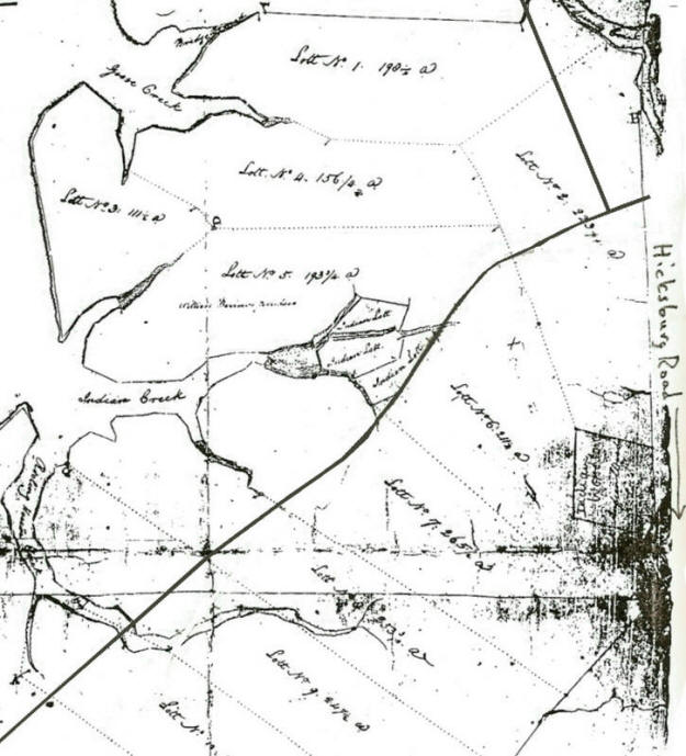
This c.1800 plat is of Choptank Indian Lands in the vicinity of Indian Creek, showing the lots of Indian land properties purchased by landowners of that period. The lots can be identified from U.S. Census records. Note there are two locations of remaining Indian land shown on this plat. The present locations of Routes 16 and 14 have been approximated on this map for convenience. The following landowners were identified from an abstract of 1850 U.S. Census records, compiled by Debra S. Moxey in 1994. The corresponding lot numbers from the c.1800 plat of Choptank Indian Lands were estimated and identified by John Creighton:
Lot No. Property Owner
Lot 1 William Hollan
Lot 2 Harry Handley
Lot 3 John Stewart
Lot 4 John Pattison
Lot 5 Thomas B. Sherman
Lot 6 Tilghman Cheezum
Lot 7 Thomas M. Flint
The Indian Lands identified on the c.1800 plat nearest Indian Creek are speculated but not verified as possibly being property identified in the 1850 U.S. Census occupied by heads of households Ann Banks and William Harrison.