The Bowen Family
Lee Co., VA / Hancock Co., TN
Robert Bowen
The Vestry Book and Register of Bristol Parish, Virginia.
Robert Bowen and other Bowens are found on the Tithe Lists of Lunenburg
Co., Va. in 1748, 1752 and 1764. In 1768 Drury Bowen and Robert Bowen
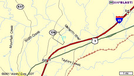
were granted 425 acres on the south side of Meherrin River and on Eagles
Nest Creek (Mecklenburg Co., Va.). (Elliott, Early Settlers of
Mecklenburg County, Virginia, Volumes 1 and 2.) Mecklenburg was formed
from Lunenburg in 1764-5.
http://www.geocities.com/fcullom/
There may have been more than one Robert Bowen who left records in Bristol Parish, Brunswick, Lunenburg, and Mecklenburg. With the records we have now, it's impossible to be sure. We know that a Robert Bowen with wife Avis were the parents of Ephraim Bowen and Lucie Bowen, both born in Bristol Parish during the same period when William Bowen Sr's children were born.
Lucie D of Robert and Avis Bowen born
23th August 1730
Ephraim son of Robt & Avis Bowen born
12th Feby 1731 bapt 30th July 1732
At first, it would appear that Ephraim's birth was less than nine months after Lucie's birth, but the year didn't change until March 25 by the old calendar. By our modern calendar, we would say that Ephraim was born on 12 Feb 1732 which would separate the children by 18 months. We have no way of knowing if there were other children born before or after these since the records for the births and baptisms of the children born to William Bowen and Robert Bowen in Bristol Parish spanned only five years from 1729 to 1734.
A Robert Bowen began appearing in the Brunswick Co records shortly after William Bowen Sr did. This Robert's first record in Brunswick Co was dated 2 Apr 1741. That record and another following it revealed that an order of attachment had been levied against Robert Bowen, garnishee of William Moore's estate. William Moore was a very common name and I have not been able to find any other records for a William Moore that I feel sure was this one.
The records for Robert Bowen picked up in Lunenburg Co when that county was formed from Brunswick Co in 1746. However, there was a 5 year gap between his last Brunswick Co record in 1747 and his first Lunenburg record in 1752. This gap could be significant.
Order Book 2 1/2A, p 142
John McLain agst Robt Bowen defendant in debt;
attachment (knife & fork); public sale ordered for sd attachment
July Court, 1752
Order Book 2 1/2A, p 561
Wm Maynard agst Daniel Ealbank defendant; jury: .....
Robt Bowen ....
March Court, 1753
Order Book 2 1/2A, p 570
Robert Wade Jr agst Mathew Tanner defendant; jury: .....
Robt Bowing ....
March Court, 1753
Order Book 2 1/2A, p 575
John Richardson agst John Goad Jr defendant; jury: ....
Robert Bowing ..... Robt Andrews .....; plaintiff to recover damages
March Court 1753
A Robert Bowen clearly owned land and was living on the south side of the Meherrin on Eagles Nest Creek by 1753, but no record has been found to explain how he obtained his land or exactly how much land he originally held. As a matter of fact, there seems to have been some problem with lost or mishandled patents for several people who held land in the northeastern part of present Mecklenburg Co. The patents and deeds reflect that Robert Bowen, Edward Henry, Margaret Bagwell, and William Wright all held surveyed land in the area - but no patents exist for them and there is no sign that they purchased their land from previous landholders. This caused some problems, especially where the land of Robert Bowen, Edward Henry, and John Clack was concerned.
Lunenburg DB 3, p 396
7 Nov 1753 Robert Bowen of the Parish of
Cumberland and County of Lunenburg to Clement Read of same parish. 10
pounds. Land adjoining the lands of Edward Henry on the Eagles Nest
Creek and is the land whereon the said Robert Bowen now lives containing
150 acres.
Signed Robert + Bowen.
Witnesses Chas. Cupples, P Carrington, Robert Wooding
At court 7 Nov 1753… acknowledged by Robert Bowen
Lunenburg Deed Book 3, p 404
11 May 1753 Robert Bowen of the Parish of
Cumberland in the County of Lunenburg to Clement Read. 10 pounds, 7
shillings, 1 penny. One 2 yr old steer, 3 yearling steers, 1 yearling
heifer, 1 cow and yearling seer [sic], and 1 cow and bull calf mark'd
with a swallow fork in the right ear and a slit in the left ear.
Signed Robert + Bowing
Memorandum: Tis agreed by and between the within named
Robert Bowen and Clement Read that the cattle that is the breeding
cattle within mentioned shall remain with and be in the possession of
the said Bowen on half stocks so long as the said Read shall see fit,
Bowen to have half what he raises, Read the other half and Bowen to make
good the principal when the stocks raised are divided and Bowen to drive
to the house of the said Read steers such as are his when thereto
required.
Signed Robert + Bowing
Wit Paul Carrington
At a court continued & held for Lunenburg County the 7th
day of Nov 1753 the within written mortgage and the above memorandum
were by the above named Robert Bowen acknowledged….
These deeds were again reflected in the Lunenburg Order Books:
Order Book 2 1/2B, p 511
Robt Bowen to Clement Read, indenture bargain/sale
Robt Bowen to Clement Read, b/sale
November Court, 1753
No patent or deed to Edward Henry has been found. No patent to Robert Bowen has been found until much later. However, several other patents mention their land as adjoining. One such patent was William Bowen's patent of 1761 (surveyed at some unknown previous date) which was farther up the Eagles Nest Creek and on both sides of the creek. The northeastern boundary of his land was formed by a short 18 pole line on Henry's land and a branch which eventually flowed into the Eagles Nest Creek. Robert Bowen's land was on the other side (west side) of the creek forming two of the northwestern lines of William Bowen's patent. We can't tell whose land was on the other side of this branch or even exactly where the branch flowed into the creek, but we do know that Henry's land was somewhere on the northeast side of William Bowen's land.
The 1756 patent to John Roberts describes part of Henry's land. "...Vaughan's corner in the same thence along his [Vaughan's] line north seven degrees east one hundred sixty four poles to a Spanish oak thence a new line north thirty degrees east sixty five poles to Henry's line thence along his [Henry's] line south [unreadable] five degrees east one hundred and six poles to a red oak on Island Creek thence down the stream as it meanders to the first station [the river]." The Spanish oak was the same Spanish oak at the southeastern corner of William Bowen's land. George Vaughan's land adjoined William Bowen's land on the south side. The new line to Henry's line was the same 65 pole line on the east side of William Bowen's patent which cornered at Henry's line. But the John Roberts patent goes on to describe Henry's line as extending to Island Creek farther east. Robert's land was south of this line while Henry's land was to the north.
The John Roberts land was evidently repantented by William Robertson in 1769. That patent again described Henry's line. "Beginning at a beech on the river at the mouth of the creek thence up the creek as it meanders to Edward Henry's corner hiccory and red oak saplin on his line north fifty five degrees west one hundred and sixteen poles to his own corner small white oak thence Vaughan's corner Spanish oak in Vaughan's line south six and an half degrees west one hundred and seventy six poles to a black jack on William Munford's line..." Although we still don't have the full description of Edward Henry's land, we do know that it extended from Island Creek westward overlapping at least the northeastern corner of William Bowen's land where Bowen's line became the branch that flowed into the Eagles Nest Creek. Some of Henry's land may have continued on the north side of this branch, but we can't tell because there was no patent to Edward Henry.
John Clack's patent was also in the same area. It was so much in the same area that it was the same land! This was undoubtedly Edward Henry's land! But the line this time is 124 poles - that includes the 16 poles that formed the short leg of William Bowen's line. The branch that flowed into the creek in Clack's survey is the same branch that formed William Bowen's line. Bowen's patent referred to the branch but never stated whose land lay on the other side of it.
Patent to John Clack. 10 June 1760. 330 acres Lunenburg Co on the south side of Meherrin River. Beginning at a red oak on Island Creek thence a new line north fifty five degrees west one hundred and twenty four poles to a white oak at the head of a branch of the Eagles Nest thence down the said branch to the creek and down the creek as they meander to the river thence down the river as it meanders to the mouth of Island Creek and thence up the same as it meanders to the first station. Patents 34, p 509, 510
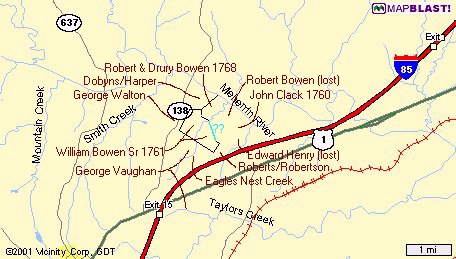
An 1870 map of this part of Mecklenburg Co shows the branch that separated Clack's land from William Bowen's land exactly where we would expect it to be. But this 1870 map does not extend far enough east to show Island Creek. Notice Harper's Road and Harper's Old Bridge shown on this map just west of Smith Creek. The John Harper land will become important too.
The description of Clack's survey indicates that John Clack was patenting all the land between Eagles Nest Creek and Island Creek north of his 124 pole line and the branch that formed the southern boundaries of his land. This not only included the land that was previously referred to as Edward Henry's land, it also included the 150 acres adjoining Edward Henry that Robert Bowen had deeded to Clement Read! Obviously Robert Bowen was under the impression that the land belonged to him. He was also under the impression that the land on the west side of Eagles Nest Creek on the river belonged to him, but there was no patent granted for that land either until 1768.
It's not clear exactly what happened here. Apparently Robert Bowen had applied for a patent and had had the land surveyed. Bowen's line is mentioned as a pre-existing line in the William Dobyn's patent of 1755 - "thence new lines east three hundred and twenty six poles to Bowing's corner red oak thence on his line north fifty degrees east one hundred and fifty four poles to a white oak on the river thence up the same". Even though the land had been surveyed for a patent prior to 1755, something went wrong and Bowen's patent was never granted. The remaining 125 acres on the west side of the creek was eventually granted in 1768 to Robert Bowen and Drury Bowen.
It was probably this land dispute between Bowen and Clack that resulted in the following record:
Order Book 2 1/2B, p 265
John Clack agst Robt Bowing dfdnt; plaintif to recover
agst Bowing & Jas Mitchell sherif
July Court, 1753
Apparently Clack had had the land surveyed for his patent by 1753 and was not happy about Bowen deeding part of the land to Read. Bowen had to pay Clack for the land he had lost to Read - land he had thought was his own - land he received no additional money for because it had been his security for a loan. If he couldn't afford to pay back the loan, he sure couldn't afford to pay Clack for the land either. This must have been quite a financial blow. Edward Henry apparently lost his land to Clack too as there was no grant to Henry, but I haven't looked for Henry's records. Clement Read must have acquired a clear title to the land that Bowen had deeded to him as he sold part of it four years later.
Lunenburg DB 4:534
4 Aug 1757. Clement Read to Leonard Claiborn Jr. of
Dinwiddie Co., £5, 100 acres in Cumberland Parish in Lunenburg, being
part of the land Clement purchased of Robert Bowen. No witness.
We still don't know exactly where this 150 acres was that Robert Bowen believed was his, but since his land on the west side of the creek was never granted until years later, most likely this 150 acres was originally part of the same tract extending to the east side of the creek as far as Henry's land which adjoined Island Creek north of John Robert's line. Surely this 150 acres was north of William Bowen's land on the east side of the creek. It's not known if both William and Robert Bowen applied for their patents at the same time, but Robert's land was surveyed before William's (by hours? days? years?) since William's patent refers to Robert Bowen's established lines.
Order Book 2 1/2B, p 559
Wm Clinch, Wm & Thos Merriot agst Robt Bowing dfdnt;
plaintifs to recover debt
February Court, 1754
Order Book 3, p 73
Reuben Searcy on attachment agst effects Robt & Wm Bowen
dfdnts; complainant agrees to dismiss
June Court, 1754
Order Book 3, p 251
Jas Mitchell agst Robt Bowing &
John Bowing
dfnts in debt; dismissed
December Court, 1754
Order Book 3, p 251
Hicks & Friend agst Robt Bowing dfdnt; petitioners to
recover debt/costs
December Court, 1754
[There were a number of cases involving Hicks & Friend.
This might have been a business of some sort.]
Order Book 4, p 49
Jas Mitchell agst Robt Bowing & Wm Bowing dfdnts; jury:
[list of names]; plaintif to recover damages agst dfdnt Wm & Wm Mize &
Wm Boing Jr his bail.
November Court, 1755
James Mitchell, sheriff, had been named as a defendant with Robert Bowen in the Clack case. Was this relating to the same case?
Lunenburg DB4 p 293
Nov 19, 1755 from William Saffold of Lunenburg, planter,
to Theophilus Field of the County of Prince George, merchant. Saffold
owed Field 40L, hence this indenture to better secure the payment of the
debt. Saffold, for securing the debt and for 5 shillings, grants to
Field all that plantation where Saffold lives, containing about 133
acres and bought of Henry Tally, & lies in Lunenburg, being bounded by
Andrews, north side Meherrin River, a new line, Capt Booker. If Saffold
repays Field within 5 years, then this mortgage becomes void. Signed -
William Saffold.
Wit Henry Parrish, Robert (X his mark) Bowen, James (+
his mark) Daws, James (T his mark) Thomason, Theophilus Field Jr.
Recorded Aug 3, 1756.
Order Book 5, p 83:
May Court 1758
William Bowing plaintif against Ephrahim Bowing
defendant in debt. The parties having agreed the difference subsisting
between them therefore this suit is ordered to be dismissed.
Order Book 5, p 88:
June Court 1758
Ephraim Bowen petitioner against Thomas Wright defendant
on a peto. It was ordered that 2 pounds 10 shillings be paid to Bowen.
Order Book 6, p 10
June Court 1759
Wm Bowing agst Ephraim Bowing dfdnt in debt; plaintiff
to recover agst dfdnt & Lyddal Bacon sheriff.
Although Robert Bowen and wife Avis's son Ephraim Bowen was 16 by 1748, Ephraim was not listed under Robert Bowen on the 1748 Lunenburg tithes list or any other later tithes list even though a Robert Bowen was listed several times. Actually, Ephraim Bowen did not appear in the Lunenburg Co records at all until 1758 when he first appeared in the Lunenburg Co Order Books. He would have been age 27 at that time. Ephraim's last record in the Lunenburg Order Books was in 1765. He was in Albemarle Co, VA by 1766. Why was Ephraim not reflected in any of the Lunenburg records until 1758?
So this raises the question - was the Robert Bowen who appeared in the Lunenburg records the father of Ephraim or a different Robert Bowen? If he was a different Robert Bowen, what about the Robert Bowen in the Brunswick Co records? Which one was he? Does the 5 year gap between the Brunswick Co records for Robert Bowen and the Lunenburg Co records for Robert Bowen signify anything?
Order Book 6, p 202
Jas Williams aptd surveyor rd from Three Mile Tree to
head of Haw branch to cart path leading from Caliham's Rd to the Chappel,
with assistance Geo Vaughan, Saml Kirk, Jas Thomason, Jas Campbell,
Abraham Merriman, Epharim Bowing, Wm Sho[?]le, Henry C[h]avus, Wm
Slaughter, Wm Bowing Sr, Robt Bowing, Jesse Brown, Wm Bowing Jr, David
Bowing, Isaac Johnson, Jas Williams.
December Court, 1760
[Was Jesse Brown a misrecording or mistranscription for
Jesse Bowen?]
Order Book 7, p 106
Robert Bowing for reasons appearing to the court to be
exempted from payment of Public & Court levies for the Future.
1761
Why? Age? Financial hardship?
Order Book 8, p 10
Richd Hanson agst Robt Bowen dfdnt in debt; judgmnt
granted.
April Court, 1762
Order Book 10, p 28 (1764-1765)
Richard Hansen against Robert Bowen, who has to pay 150
lbs tobacco to Hansen
Order Book 10, p 183 (1764-1765)
Lewelling Jones against Robert Boing for 1 pound
Order Book 11, p 177 (1765-1766)
David Garland against William Bowen & Robert Bowen
On 20 July 1768, Robert Bowen and Drury Bowen were
granted a
patent for 125 acres in Mecklenburg Co on the south side of the
Meherrin River on Eagles Nest Creek. The tract was described as:
Beginning at a posimmon tree on the Eagles Nest Creek
thence north forty eight degrees west forty eight poles to a hickory
thence north twenty three degrees east forty four poles to a red
oak thence north fifty degrees
east one hundred and sixty eight poles to a white oak on Meherrin River
aforesaid thence down the meanders of the said river to the mouth of the
Eagles Nest Creek aforesaid thence up the meanders of the said creek to
the beginning.
The underlined portion matches the surveyed lines in William Bowen's 1761 patent. The italics portion matches the surveyed line in William Dobyn's 1755 patent. There is no doubt that this land was in the possession of Robert Bowen many years before this 1768 patent was granted, perhaps even before 1750 since Doybn's land had no doubt been surveyed several years before his patent was granted. If Robert Bowen applied for a new patent on his remaining land as soon as the problem with Clack occurred in 1753 - surely he didn't wait long - it took 15 years for this new patent to be granted. But this time the land wasn't granted to just Robert - it was granted to Robert and Drury. Perhaps Robert wasn't able to come up with the required money alone. From the order book records, it appears that financial problems plagued him continually.
The next question is - was the Robert Bowen who held this land in the early 1750's the same person as the Robert Bowen who patented the land with Drury Bowen in 1768? Or were Robert and Drury heirs of the earlier Robert and, upon inheriting the land, realized there was a problem and applied for a new patent jointly? I don't believe there were two Robert Bowens involved here. Surely after the Clack incident, that Robert Bowen was aware there was a problem involving his claim to the land and he could lose the remaining part of his land on the west side of Eagles Nest Creek the same way. Although it took another 15 years to finally obtain a grant, I believe this was the same Robert Bowen. Considering the financial setbacks he had just been through with the mortgage and then having to pay Clack for the land too, I suspect Robert needed Drury's financial assistance and was willing to share the land with Drury in return.
Robert Bowen mortgaged part of his remaining land in 1770.
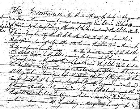
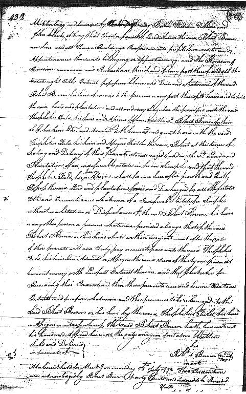
Mecklenburg Deed Book 3, p 431, 432:
13 July 1770 Robert Bowen of the County of
Mecklenburg Planter to Theophilus Field of Prince George County ...
Robert Bowen stands justly indebted unto the said Theophilus Field in
the sum of Thirty one pounds Current money ... parcel of land containing
one hundred acres more or less ... bounded by [the land of?] Drury
Bowen, William Dobbins and John Clack it being that Tract or parcell of
Land whereon the said Robert Bowen now lives ... if the said Robert
Bowen or his heirs shall within two years next after the ??? of these
presents will and ??? pay or cause to paid unto the said
Theophilus Field ... the said sum of thirty one pounds ... then these
presents ??? and become void to all Intents and purpose ...
Signed Robt (+) Bowen
Witnesses [None given]
At a Court held for Meck.g on Monday 13th July 1772 This
Indenture was acknowledged by Robert Bowen party thereto and ordered to
be Recorded.
Since the deed was not recorded immediately, but held
and recorded exactly two years later to the day, from this record alone,
it looks like Robert Bowen must have defaulted on the loan and lost this
land too, and Field was taking possession. Why else would Field be
recording the deed at exactly two years later? This was certainly part
of the 125 acres that had finally been granted to Robert Bowen and Drury
Bowen in 1768.
But apparently the land wasn't lost. Maybe at the last minute, Drury or someone else came up with the money to bail him out of this jam. Half of this patent can be found in a deed about 20 years later and the other half a few years after that - still in the possession of Robert and Drury.
Mecklenburg Deed Book 5, p 225
8 April 1778 Edward Dobyns of the County of
Frederick on the one part and John Harper of the County of Mecklenburg
on the other part ... sum of one hundred and fifty pounds ... three
hundred acres more or less ... Beginning at Richard Whitehead's lower
corner white oak on Meherrin river thence down the said river to Drury
Bowens corner on the river thence along his line to Charles Bowen's line
thence along Bowens line to a new corner made on said Bowens line
for Richard Whitehead thence down the new line to a new corner on a
white oak just above his crop fence thence down the said Whiteheads line
to the beginning the same being granted to the said Edward Dobyns ...
Signed Edward Dobyns
Wit Richard Whitehead, William Drumright, Charles (X)
Bowen, James Atkins, James (X) Bowen
Memorandum that quiet and peaceable possession was this
day had ....
Signed Edward Dobyns
Wit Richard Whitehead, William Drumright, Charles (X)
Bowen, James Atkins, James (X) Bowen
At a court held for Mecklenburg County the 13th day of
April 1778 this indenture & the memorandum endorsed were proved by the
oaths of Richard Whitehead Charles Bowen & William Drumright witnesses
thereto & ordered to be recorded.
Again, a deed contained incorrect information concerning the original patent. The land was not granted to Edward Dobyns; it was granted to William Dobyns.
Patent to William Dobyns. 10 September 1755. 400 acres Lunenburg Co south side of Meherrin River. Beginning at Noble's corner white oak on the same thence on his lines south sixty three degrees west three hundred and thirty poles to a hiccory in Hagood's line thence on his line south ten degrees east sixty four poles to a hiccory and white oak thence new lines east three hundred and twenty six poles to Bowing's corner red oak thence on his line north fifty degrees east one hundred and fifty four poles to a white oak on the river thence up the same. Patents 31, p 555
The following deed on the same date as the Dobyns/Harper deed, 8 April 1778, was from the same Edward Dobyns to Richard Whitehead of Mecklenburg Co. This accounts for the remaining 100 acres from the William Dobyns patent. (Mecklenburg DB 5, p 226)
"...one hundred acres more or less ... Beginning at a corner white oak just above Richard Whitehead's crop fence thence [north] up the said Whitehead's line to Isaac Johnson's corner hickory thence [east] along the said Johnson's line to James William's and Charles Bowen's corner thence [south] along the said Charles Bowen's to a new line thence [west] down the new line to the beginning, the same being granted to the said Edward Dobyns..."
From the Edward Dobyns deeds, we can see that the Robert Bowen land had been divided with Drury Bowen taking the half on the river and Charles Bowen taking the land behind that. How did Charles Bowen come into possession of the half that should have been Robert Bowen's? Or is this another error in a deed? Charles Bowen did purchase 200 acres from George Walton in 1770 south of Dobyns land and east of what had been William Bowen's 1761 patent (the part that was deeded to Samuel Kirks in 1762 and then sold to David Bowen in 1770). Is the Dobyns deed referring to that land?
Regardless, it's apparent from the next deed that Drury Bowen did in fact hold the half of the land that adjoined the river, so the remaining half behind that should have still been in the possession of Robert Bowen.
Mecklenburg Deed Book 6, p 502:
17 March 1785 Drury Bowen and Elizabeth his wife
and Robert Bowen Senr of the County of Mecklenburg to Charles Bowen of
the County aforesaid ... sum of one hundred pounds currt. money ...
sixty one acres be the same more or less and bounded as followeth (to
wit) Beginning at the eagle nest Creek on the mouth thence up the river
[west] to John Harpers Corner ... [south] along the said Harper's line
to Robert Bowen's Corner ... by a new markt line [east] to the said
Creek thence down the Creek [north] to the Beginning the same being
granted to the said Drury and Robert Bowen ...
Signed Drury Bowen, Elizabeth (EB) Bowen, Robert (RB)
Bowen
Witnesses David Bowen, Little Berry (E) Bowen, Isham (B)
Bowen, Geo. Connelly Junr.
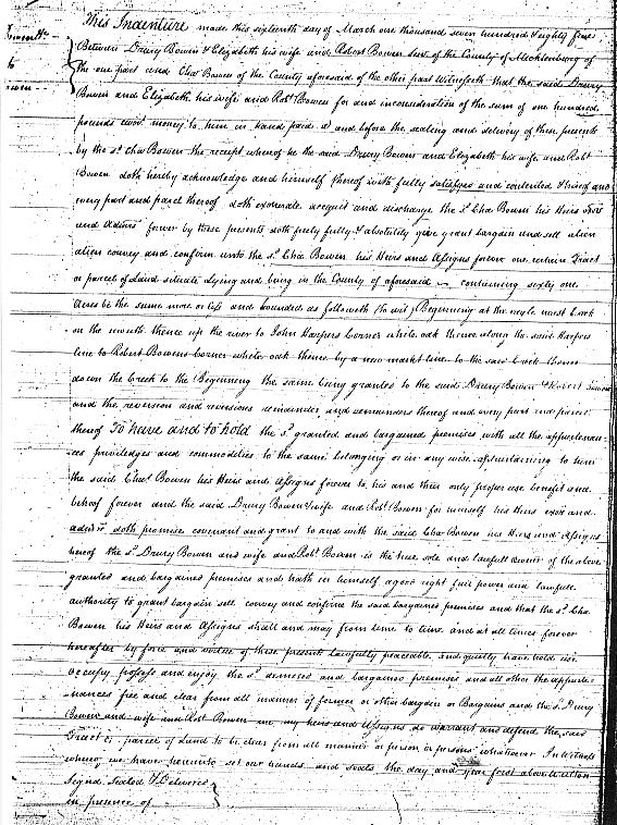
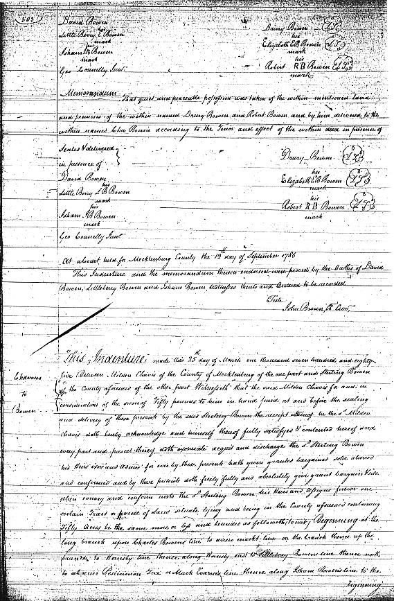
According to this deed, Drury held the northern half of the patent, the half adjoining the river, which he was selling to Charles. Since the patent was granted to Drury and Robert, Robert was also a grantor. That much agrees with the Dobyns/Harper deed. But this deed indicates that Robert Bowen still held the southern half of the patent behind Drury.
Robert Bowen who patented this land with Drury Bowen is now styled "Sr", implying there was a younger Robert Bowen in the area (not necessarily his son). However, I have never seen a record for a Robert Bowen "Jr" or any younger Robert Bowen during this period.
Robert Bowen was certainly in possession of the other half of the patent until his death as proven by the following deed. But the following deed seems to be full of confusion as well.
Mecklenburg Deed Book 8, p 401, 402:
22 Dec 1792 James Bowen, Martha Bowen, and Mary Evans,
legatees of Robert Bowen's estate deceased of Mecklenburg Co to Charles
Bowen and James Bowen of the country aforesaid. ... for diverse
good causes themselves hereunto moving but more especially for and in
consideration of the just and fare(?) sum of three pounds current money
of Virginia ... parcel of land containing by estimation sixty acres
adjoining the lands of John Nash Senr, Jesse Bowen, Mark Evans, Senr and
the said James Bowen and John Harper and the said Drury Bowen ...
Signed Mary (+) Evans, Martha (+) Bowen, James (+) Bowen
Witnesses James Williams, Wm. Drumwright, Richard
Whitehead
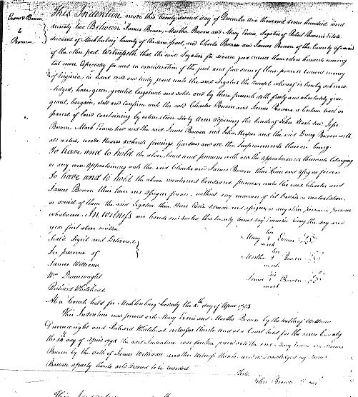
This is a very confusing record. How many James Bowen's were involved? One was a legatee and the other was a grantee. Were they the same person or two different people? A James Bowen has been found who was probably one or the other - but which one, the grantor/legatee or the grantee? Or was he both? Mary Evans and Martha Bowen have not been found in the later records.
Notice the difference in the amounts paid for these two tracts. Charles paid Drury 100 pounds for his half, but Charles and James paid just 3 pounds for Robert's half.
No will or estate records have been found for Robert Bowen and he almost certainly died intestate. Drury was not named as a legatee, so he probably wasn't Robert's son. It's more likely Drury and Robert were brothers. But why was the expression "the said Drury Bowen" used in this deed when there had been no previous reference to Drury? Neither Ephraim nor any of his children were named as legatees, so this probably was not the same Robert Bowen who married Avis.
Some clues may lie in the Evans family records. The Bowen deeds frequently mention the adjoining land of Mark Evans. But there were two Mark Evans - a Sr and a Jr. In 1777, David Bowen (son of William Bowen Sr) and wife Anne sold 90 acres on Eagles Nest Creek to Mark Evans. No Sr or Jr notation was used. According to this deed, the land adjoined Littleberry Bowen, James Bowen, Isham Bowen, and Robert Bowen. This would seem to be the Mark Evans Sr land referred to in the 1792 deed by Robert Bowen's legatees.
The will of Peter Andrews (son of John Andrews and grandson of Thomas Andrews Sr of Henrico Co - also see other Andrews records) named daughter Winifred Evans. Mark Evans Jr's later will named wife Winifred, thereby proving his wife as Winifred Andrews. The research of Tom Evans states that Mark Evans Sr was born about 1733 and names his wife as Francis. I have not been able to verify this and don't know what record this came from or the date of that record. However, on 25 Apr 1804, Mark Evans and wife Elizabeth sold 90 acres to John Harper (Jr). The description mentions Eagle Creek on Berry Bowen Sr's line (Littleberry Bowen), so it would seem to be the same 90 acres that David Bowen had sold to Mark Evans in 1777. Unless Mary Evans died between 1802 and 1804 and Mark Evans Sr remarried, Mary Evans would not seem to have been the wife of either Mark Evans Sr or Jr. Perhaps Mary Evans was the wife of another of Mark Evans Sr's sons.
June Banks Evans suggested that Mary Evans might also have been the widow of Robert Bowen who had remarried into the Evans family. Mary remains a mystery.
From the above deeds we can determine that this Robert Bowen died between 1785 and 1792. The land tax records help to pin his death date down more as he was listed with 60 acres in 1787 and 1788, but from 1789 to 1792 the same 60 acres was labeled "est" which probably indicated this was estate land. In 1793, Robert Bowen was listed with "no land" which agrees with the sale of the 60 acres in 1792.
Lunenburg Deed Book 7, p 262
24 May 1762 William Bowen Senr of Saint James Parish in
Lunenburg to Samuel
Kirks ...
consideration of the natural love... 70 acres it being part of a track
of 240 acres granted 14th Feb 1761 to the said William Bowen ... on the
Eagles Nest Creek between a branch called the Buck branch and Robert
Bowen's spring branch joining the land of
Robert Bowen
and the land of George Waltons and joining the land of James Thomason
and the other part of the said land divided by the Eagles Nest Creek and
the Buck Branch and Robert Bowens spring branch between the said Samuel
Kirks and the other part of the land mentioned the said patent...
Signed William (+) Bowen, Amey (a) Bowen
Witnesses Robert (+) Bowen, Drury (D) Bowen, Elizabeth
(E) Nawblin [Noblin]
Rec 1 June 1762
Because of the reference to George Walton's land which adjoined William Bowen's 160 pole line on the west, we know Kirks' part of William Bowen's land must have been on the west side of his 1761 patent. Similar deeds were made the same day to son Jessey [Jesse] Bowen and David Bowen for 70 acres each. Jesse's deed mentioned Clack's land as adjoining, so his part must have been on the east side of William's patent, with David's part somewhere in the middle. All three deeds were witnessed by Robert Bowen, Drury Bowen, and Elizabeth Nawblin [Noblin?].
Mecklenburg Deed Book 2 p 386
11 May 1770 Samuel Kirks to David Bowen. 25 pounds. 70
acres on Eagles Nest Creek. Beginning on the creek at Robert Bowens line
thence South along Robert Bowens line to David Bowens line on the Buck
Branch thence west up the Buck Branch to Warton's [sic] line thence
north along Warton's line to Robert Bowens line thence east along Robert
Bowens line to the beginning at the said Eagle Nest Creek ...
Signed Samuel (X) Kirks, Edy (X) Kirks
Wit George Vaughan, Abram (X) Merrymoon, James Cammell
Rec 14 May 1770
Again we see a seriously flawed deed. There is absolutely no way to make this description work with the original patent, no matter where you place the land. The deed for this same land from William Bowen Sr to David is so poorly worded that even with it to help, there is no way to determine exactly what the lines were. Anyone who tried to use this deed to try to figure out Robert Bowen's lines and David Bowen's lines would be in serious trouble. Robert Bowen's lines that adjoined William Bowen's lines simply did not run as described in this deed. But in spite of all the errors, the land that Kirks sold to David Bowen is still recognizable as the same land that William Bowen deeded to Kirks.
Notice that Robert Bowen, Drury Bowen, and Elizabeth Noblin witnessed all three deeds when William Bowen Sr divided his land prior to his death. William Bowen Jr already held land of his own and was not included. William Bowen Sr seems to have been trying to provide for his children who had no land of their own.
If Robert Bowen of the Lunenburg and Mecklenburg records was not the father of Ephriam Bowen, who was he? Were Robert and Drury brothers? Robert was of age by 1753, perhaps earlier since we know he held land at that time. So he was born by 1731. Drury served on a jury in 1759, so he was a landholder and at least age 21, so born no later than 1738 and possibly earlier. If Drury and Robert entered the land for a new patent in 1753 or very shortly after the Clack problem, then Drury might have been born before 1731. They both seem to have been born during the same period when the children of William Bowen Sr and Amy and Robert Bowen and Avis were born. Considering all the records, could they have been unproven sons of William Bowen Sr?
When George Walton divided and sold his land that adjoined the western line of William Bowen Sr's patent in 1770, William Bowen Jr, Charles Bowen, William Drumright (whose wife was a daughter of William Bowen Jr), Laborn Stafford, and Thomas Noblin bought tracts. Since so many of these were members of the Bowen family, perhaps Elizabeth Nawblin [Noblin?] who witnessed the deeds dividing William Bowen Sr's land should be examined as a possible Bowen daughter. If Robert and Drury (who also witnessed this deed) were possible additional sons of William Bowen Sr, could Elizabeth have been a daughter? Was William Bowen Sr asking some of his other children to witness the division of his land so there could be no misunderstanding later?