East New Market
Property Reports
40 Academy Street
East New Market High School
Key date analysis:
coming soon...
Who built it:
A
Longest Residents:
D
More Research:
e.
Historic Records:
383 MLB 588 - 28 August 1998 - Board of Education to the Commissioners of East
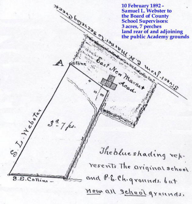
New Market for $10: Whereas by deed dated 10 February 1892 in 16 CL 333,
Samuel L. Webster & Priscilla A. Webster, his wife, conveyed a certain tract of
land believed to contain 3 acres and seven square perches of land to the Board
of School Commissioners. Whereas the remainder of said original tracts
were subsequently conveyed by the Board of Education unto the County
Commissioners of Dorchester County by deed dated 7 August 1975 in 192 PLC 105
and by deed dated 12 April 1977 in 202 PLC 214. Whereas that by a deed
dated 3 January 1978 in 203 PLC 577, the County Commissioners conveyed all those
lots which it owned to the Commissioners of East New Market. Now therefore
conveys the following:
Parcel No. 1: 3.7 acres located on the south side of Academy Street; See
Tax Account No. 02-029685, Map 200, Parcel 107.
Pacel No. 2: 13,125 square feet on the south side of Maryland Rt. 14; See
Tax Account No. 02-032015, Map 200, Parcel 108.
Both of these parcels being more fully described in the Deed from the County
Commissioners to the Commissioners of East New Market dated 3 January 1978 in
203 PLC 577.
203 PLC 577 - 3 January 1978 - The County Commissioners of Dorchester County to
the Commissioners of East New Market for $5: Two parcels:
Parcel No. One - All of that lot delineated on a Plat of Survey dated
July 1975 and prepared by Andrews, Miller, & Associates, Inc., in 16 PLC 52.
Beginning at a concrete monument set on the southwesterly side of a concrete
sidewalk bordering Maryland Route 14 leading from East New Market to Secretary,
and from said point S37/16W 175 feet to another concrete monument, thence N54W
75 feet to another concrete monument, thence N37/16E 175 feet to another
concrete monument located on the southwest side of the concrete sidewalk
aforesaid, thence with the southwest side of said concrete sidewalk S54E 75 feet
to the place of beginning. Containing .3 acres. Being the same land
which was conveyed unto the County Commissioners of Dorchester County by the
Board of Education by deed dated 7 August 1975 in 192 PLC 105.
Parcel No. Two - Six lots in or near the corporate limits of
the town of East New Market
Lot No. 1: All that lot conveyed unto the Board of
Education by deed dated 16 June 1874 in 9 FJH 431. Beginning at the
northwest corner of the Old Academy Lot, thence S29W 7p, thence N51/45W 3 8/25
p, thence N30/15E 6 4/5 p, thence by a straight line to the beginning.
Containing 1 rood and 3 square perches.
Lot No 2: All that lot conveyed unto the Board of
Education by deed dated 15 June 1874 in 9 FJH 475. Beginning at a
stone set down on the road leading from East New Market to Secretary Creek, and
being near the Protestant Episcopal Church building in said town and thence
running S31W 12.5 p to the 2nd line of Causine Helsby's land, thence with said
2nd line reversed S60E 6.4 p to the end of the first line of Causine Helsby's
land, thence N31E 12.5 p to the road leading from East New Market to Secretary
Creek, thence with the road in a straight line to the place of beginning.
Containing 1/2 acre.
Lot No. 3: All that lot conveyed unto the Board of Education by
deed dated 7 September 1891 in 15 CL 725. Beginning at a marked scrub oak
standing on the south side near the edge of the main road leading from East New
Market to Secretary landing, and thence running N59W 8 p to a marked stone
standing by the edge of said road, thence S31W 8 p to a white oak, thence S59E 8
p to another marked stone and thence by a straight line to the beginning.
Containing 64 square perches of land.
Lot No. 4: All that lot conveyed unto the Board of
Education by deed dated 23 March 1923 in 12 JFD 672. Beginning at a maple
on the east side of the county road and on the south side of a ditch, thence
with the east side of the county road N34W 56f to a stake, N22.5W 105f to a
stake, N1.75E 56f to a stake, N30.75W 90.5f to the center of a ditch, thence
with said ditch S65.75E 206f to the center of another ditch and E.W. Wheatley's
line, thence with said line and ditch S26.5W 220f to a stake in said ditch then
N85.5W 63f to the place of beginning. Containing 33,415 square feet,
subject nevertheless to the condition that the grantee shall drain the parcel
hereby conveyed so that it will afford proper drainage to land of the grantor
immediately adjoining said parcel.
Lot No. 5: All that lot conveyed unto the Board of
Education by deed dated 27 March 1923 in 12 JFD 673. Beginning at a point
'A' on the plat as surveyed and laid down by J.W. Noble on 9 March 1923, then
S34.75W 350.3f to a stake on the north edge of a ditch, then with the ditch
N85.5W 57f to the center of another ditch, then with said ditch N26.5E 374f to a
post on the north side of a ditch S59.5E 108.5f to the beginning.
Containing 31,608 sq. feet.
Lot No. 6: All that lot conveyed unto the Board of
Education by deed dated 31 December 1932 in 29 JFD 374. Adjoining on its
southeastern side the lot that was conveyed unto the said Board of Education by
Eben W. Wheatley & wife by deed dated 27 March 1923 in 12 JFD 673.
Beginning at the same point of beginning and running in a southeasterly
direction along and with the land of George W. Moore 60 feet, thence along and
with other property of the said Eben W. Wheatley and wife, in a southwesterly
direction, a distance of 352f 9 inches, to other property of the said Eben W.
Wheatley & wife, thence along and with other property of the said Eben W.
Wheatley & wife in a westerly direction 71f to the school property, thence with
the school property in a northeasterly direction a distance of 386f, to the
place of beginning.
Saving and excepting from Parcel No. 2, however, all of that lot conveyed by the
Board of Education to the county commissioners of Dorchester County by deed
dated 7 August 1975 in 192 PLC 105. [this is parcel one above]
Being all of Parcel 2 in a deed from the Board of Education unto the County
Commissioners by deed dated 12 April 1977 in 202 PLC 214.
202 PLC 214 - 12 April 1977 - Board of Education to the County Commissions for
$5:
Whereas there hereinafter described land is a part of all of that land conveyed
unto the board of education by deed 9 FJH 475. Whereas the hereinafter
described land and property has been declared surplus by the board of education
at its regular meeting held 8 July 1975 and is to be conveyed to the County
Commissioners of Dorchester County: [Parcel Two (6 lots) is the same
as Parcel Two in 203 PLC 577] also includes an additional parcel near
Secretary.
192 PLC 105 - 7 August 1975 - Board of Education to the County Commissions for
$5:
Whereas there hereinafter described land is a part of all of that land conveyed
unto the board of education by deed 9 FJH 475. Whereas the hereinafter
described land and property has been declared surplus by the board of education
at its regular meeting held 8 July 1975 and is to be conveyed to the County
Commissioners of Dorchester County: [same as Parcel One in 203 PLC
577]
16 PLC 52 - July 1975 -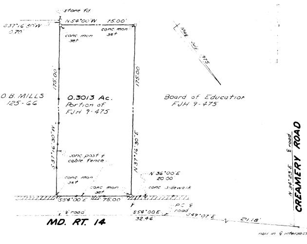
29 JFD 374 - 31 December 1932 - Eben W. Wheatley & Agnes May Wheatley, his wife, to the Board of Education for $5: lot in the town of East New Market adjoining the lot conveyed unto the Board of Education by the said Eben W. Wheatley & wife by deed dated 27 March 1923 in 12 JFD 673. Beginning at the same point of beginning and running in a southeasterly direction along and with the land of George W. Moore 60 feet, thence along and with other property of the said Eben W. Wheatley and wife, in a southwesterly direction, a distance of 352f 9 inches, to other property of the said Eben W. Wheatley & wife, thence along and with other property of the said Eben W. Wheatley & wife in a westerly direction 71f to the school property, thence with the school property in a northeasterly direction a distance of 386f, to the place of beginning. Being a part of the same land that was conveyed unto the said Eben W. Wheatley & wife by J.W. Humphery & wife by deed dated 12 June 1911 in 3 WLR 559.
12 JFD 673 - 27 March 1923 - Eben Wheatley & May, his wife, to the Board of Education for $100: lot in the town of East New Market adjoining the High School lot lying to the south of the eastern side of said High School lot extended through to the Creamery ditch, the same being bounded on the north by the High School lot, on the west by the "Creamery Lot" of S.L. Webster, on the south by the town ditch and on the east by other land of the said Board of Education and beginning for the same at a point "A" on the plat as surveyed and laid down by J.W. Noble on 9 March 1923, then S34.75W 350.3f to a stake on the north edge of a ditch, then with the ditch N85.5W 57f to the center of another ditch, then with said ditch N26.5E 374f to a post on the north side of a ditch S59.5E 108.5f to the beginning. Containing 31,608 sq. feet. Being a part of the same land that was conveyed unto Eben W. Wheatley & May Wheatley by J.W. Humphrey & wife by deed dated 12 June 1911 in 3 WLR 559.
*12 JFD 672 - 27 March 1923 - Samuel L. Webster to the Board of Education for $100: lot in the town of East New Market commonly known as the "Creamery Lot", the said lot lying immediately in the rear of the High School lot and binding therewith, and being bounded on the west by the county road known as the Creamery Road, on the south by the town ditch, and on the east by the property of Eben W. Wheatley, and beginning for the same at a maple on the east side of the county road and on the south side of a ditch thence with the east side of the county road as follows N34W 56f to a stake, N 22.5W 105f to a stake, N1.75E 56f to a stake, N 30.75E 90.5f to the center of a ditch, thence with said ditch S65.75E 206f to the center of another ditch and E.W. Wheatley's line, thence with said line and ditch S26.5W 220f to a stakein said ditch, thence N85.5W 63f to the place of beginning. Containing 33,416 square feet, subject nevertheless to the condition that the grantee shall drain the parcel hereby conveyed so that it will afford proper drainage to land of the grantor immediately adjoining said parcel.
*3 WLR 559 - 12 June 1911 -J. N. Humphrey & Eliza E. Humphrey, his wife, to Eben W. Wheatley & May Wheatley, his wife, for $3200: Lot in the town of East New Market. Beginning at the northeast corner of Mrs. Kate Varnes' lot, running south 160 ft, thence with said lot in straight line to School House ground, running west 224 ft, thence with said ground south 42 ft, thence with School House ground line west 224 ft., thence with said ground south 24 ft., thence with School ground line west 118 ft, thence with said line and Creamery lot south 344 ft to Mr. Frank Camper's lot, thence with said lot east to Mrs. Jennie Thomas's land 576 ft, thence north with said line to the county road leading to Secretary 334 feet, thence with said road to place of beginning west 60 ft. Containing 2 1/2 acres.
??? 24 CL 383 - 2 May 1900 - Emma H. Smith & James M. Smith, her husband, to Hattie D. Isenberg for $80: lot in the town of East New Market on the south side of the county road leading from said town to Secretary and described as follows. On the north fronting said county road 60 feet, thence running south 170 feet, thence west 60 feet, thence back to said road 170 feet, adjoining the lot of Mrs. Kate Varnes on the east, R.W. Randall on the south and Mr. & Mrs. Dora Smith on the west. Containing 1/16 of an acre.
*? 19 CL 398 - 25 July 1895 - Hellen Helsby, Emma H. Smith, and James M. Smith to Robert W. Randall for $275: Lot in the town of East New Market on the south side of the road leading from said town to Secretary and at the northeast corner of Mrs. Kate Varnes lot running south 160 feet thence with said lot in a straight line to school house ground running west 224 feet thence with said ground south 42 feet thence with school house line west 118 feet thence with said line & creamery lot south 344 feet to Maggie Dean's lot thence with said lot east to Mrs. Jennie Thomas land 516 feet thence north with said line to the said county road 334 feet thence with said road to place of beginning west 60 feet. Containing 2 1/2 acres.
16 CL 333 - 10 February 1892 - Samuel L. Webster & Priscilla A. Webster, his wife, to the Board of School Commissioners for $200: Land adjoining the public school grounds at the town of East New Market on the south side of the county road leading from said town to Secretary. Beginning at a stone at the southwest corner of the original school grounds and at the northwest corner of the parcel herein conveyed, thence S28/20W with a fence between this and S.L. Webster land 37 7/8 perches to a fence between this and land belonging to S.E. Collins, thence with the last named fence S87/10E 17 perches to the center of a bank between two ditches, thence with the center of said bank N24/30E 28p + 13 feet to the said original School grounds, thence with a straight line to the beginning N53/30W 18p 10f to the beginning. Containing 3 acres and 7 square perches. It being part of the "Rose Hill Farm" described in a deed from John Webster to Samuel L. Webster in 8 FJH 357.
15 CL 725 - 7 September 1891 - Vestry of New Market Parish to Board of County School Commissioners for $150: lot in or near the town of East New Market which was conveyed to the said Vestry by the Trustees of Union Chapel of New Market by deed dated 26 January 1850 in 5 WJ 421. Beginning at a marked scrub oak standing on the south side near the edge of the main road leading from New Market to Secretary Landing and thence running N59W 8p to a marked stone standing by the edge of said road, thence S31W 8p to a white oak, thence S59E 8p to another marked stone and thence by a straight line to the beginning. Containing 64 square perches. Together with the building and improvements thereon.
2 CL 84 - 6 April 1880 - George E. Varnes Jr. & Catherine M Varnes, his wife, to George E. Varnes Sr., for $700: Lot with buildings and improvements in the town of East New Market and being the same land sold by Causine Helsby to the said George E. Varnes Jr. On the south side of the road leading from East New Market to Secretary Wharf, bordering on said road with 60 feet front and running back 170 feet and adjoining the land of Corsine Helsby. Containing 1/8 of an acre more or less.
1 CL 73 - 11 January 1879 - Causine M. Helsby to Tilghman Andrews for $100: lot in East New Market beginning at a stone planted beside locust trees which are 60 feet from the northwest corner of Geo. E. Varne's lot, and on the south side of the road leading from East New Market to Secretary Creek, thence running S31W 170f, thence N60W 60f, thence N31E 170f, to said road, thence with said road S60E 60f to beginning.
12 FJH 181 - 14 December 1877 - Causine Helsby to George E. Varnes for $100: lot in the town of East New Market described as follows... Lot No 2, beginning at a stone on the south side of the road leading from East New Market to Secretary Creek, thence running S31W 170f, thence N60W 60f, thence N31E 170f, to said road, thence with said road S60E 60f to place of beginning.
9 FJH 475 - 15 June 1874 - James Dean, administrator of Thomas Helsby, deceased, to Board of School Commissioners for $100: Lot that Thomas Helsby was possessed of and which was in his lifetime sold by him to the Board of School Commissioners. Beginning at a stone set down on the road leading from E. New Market to Secretary Creek and being near the Protestant Episcopal Church building in said town and thence running S31W 12.5p to the 2nd line of Causine Helsby's land, thence with said 2nd line reversed S60E 6.4p to the end of the first line of Causine Helsby's land, thence N31E 12.5p to the road leading from East New Market to Secretary Creek, thence with said road in a staight line to the place of beginning. Containing 1/2 acre.
9 FJH 431 - 16 June 1874 - Samuel L. Webster & P.A. Webster, his wife, to Board of School Commissioners for $1: Lot near the town of East New Market beginning at the northwest corner of the old Academy Lot and thence running S79W 7p, thence N51/45W 3 8/25p, thence N30/15E 6 4/5p, and thence by a straight line to the beginning. Containing 1 rood and 3 square perches.
8 FJH 357 - 13 December 1871 - Samuel L. Webster & Priscilla Webster, his wife, to John Webster for $10,000: All of the farm or plantation called "Home Farm", or "Warwick Manor" situated in East New Market District upon which the said Samuel L. Webster formerly resided, containing 453 1/4 acres. Being the same land which was conveyed to the said Samuel L. Webster by William R. Hughlett & Lydia A. Hughlett, his wife, by deed dated 6 January 1858 in 4 FJH 143.
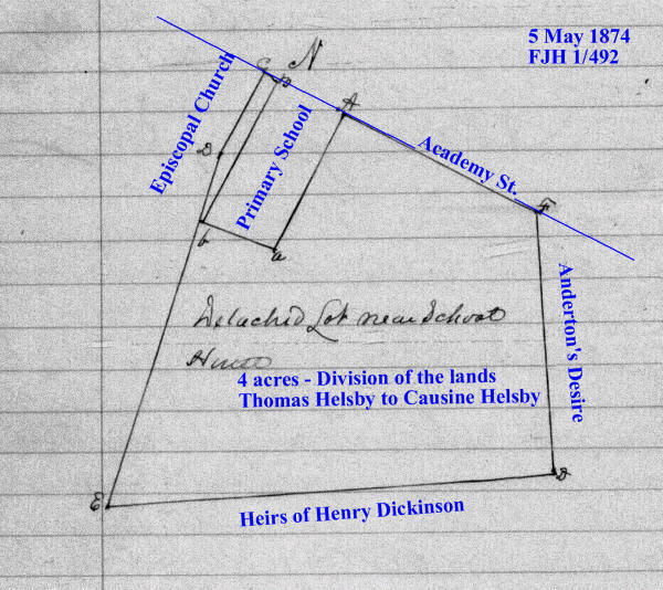
1 FJH 492 - 5 May 1874 - Causine Helsby to divide the lands of Thomas Helsby, deceased: A certain Thomas Helsby departed this life in the year 1865, intestate, and seized of certain real estate in the town of East New Market and leaving Frelinghuysen Helsby and your petitioner, the said Causine Helsby his only children and heirs at law, but the said Frelinghuysen Helsby departed this life, intestate, in the year 1872, leaving Emma Helsby his only child and heir at law, who is an infant under the age of 21 years. The petitioner prays that a commission fairly and equally in value between the parties interested. A commission of Kendall M Jacobs, John WM Dean, John W Fletcher, Thos K Smith, and Thos Leckie was appointed. The real estate situated in the town of East New Market consisting of a dwelling house & lot including an old store house & blacksmith shop on the same, and an arable lot of land detached from the dwelling house and lot and adjoining the school house in said town. Running a line from a stone on the Main Street straight to a stone near the fence of Nimrod Newton giving and allowing to Emma Helsby, infant child of Frelinghuysen Helsby, all of the lot and dwelling house and other buildings on the north of said straight line. To the said Causine Helsby, all that part of the house & lot above described lying on the south side of the line as above described running from the Main Street then intersecting with the said Nimrod Newton's fence including the old store house and blacksmith shop and also the lots of arable land detached as above described. Beginning at the east corner of the primary school lot and running with the school lot the following courses S31W 12.5p, N60W 6p 10 links, N31E 12.5p to a stone, the beginning boundary of the said school lot, thence N60W 1p to the church property, then with the church property S30.5W 7p, thence S22W 29.5p to the said land belonging to the heirs of Henry Dickinson, thence with said land N88E 32.5p to a commissioned store set down as a corner of Henry Dickinson's land and the first boundary of "Anderson's Desire", thence N 20.5p to the road leading from E.N. Market to Secretary Creek, thence in a straight line to the place of beginning. Containing 4 acres, 2 roods, and 1 perch of land.
1867-1876 Tax Record
Sarah Jane Helsby
1867 - unimproved lot $150
1866 Tax
Record
Sarah Jane Helsby
unimproved lot $150
5 WJ 428 - 23 May 1850 - Septimus Thompson & Sarah S. Thompson, his wife, of Baltimore to Thomas Helsby for $125: lot adjoining the village of East New Market which is contained within the following courses (the present graveyard excluded). Beginning at a stone set down of the south side of the road leading from East New Market to the head of Secretary Creek, it also being the east corner of the Methodist Meeting House lot, and from thence runs binding with the said Meeting house lot S 29 W 7 perches, thence leaving said Meeting house lot and running S 21 W 29 1/2 perches to the land belonging to the heirs of Henry Dickinson, thence to run and bind with said land N 89 E 35 1/2 perches to a commissioned stone set down by a commission of Henry Dickinson's land, also said to be the first boundary of "Anderton's Desire", and from thence runs N 1 W 20 1/2 perches to the aforesaid road leading to the head of Secretary Creek, thence with said road to the place of beginning. Containing 5 acres of land.
5 WJ 421 - 26 June 1850 - John H. Fletcher, John B. Leckie, William Cooper, John H. Stewart, Thomas J. Saxton, Thomas K. Smith, James Dean, Edward K. Bramble, and John Dean, Succession in Office - Henry Cleft, Thomas Thompson Jr., Christopher Norman?, Samuel Corkran, John Stevens? (of Luke), Abel? Carroll, and Thomas Troth, Trustees of the Union Chappel of New Market to John H. Hooper, William E. Harrison, Turpin Wright, Thomas Hughlett, John Stewart, Henry D. Wright, John J. Houston, and George Winthrop, Vestry of the Protestant Episcopal Church of East New Market Parish for $277: part of a tract of land called "Anderton's Desire". Beginning at a marked scrub oak standing on the south side of the main road leading from New Market to Secretary Landing, and runs N 59 W 8 perches to a marked stone standing by the edge of said road, then S 31 W 8 perches to a white oak, then S 59 E 8 perches to another marked stone, then by a straight line to beginning. Containing 64 square perches. The land & the Union Chappel or Church, except such part of said land as is now enclosed and such part of said enclosure only as is now occupied by the graves of white persons.
11 ER 567 - 5 March 1830 - Henry Nicols to Thomas H. Handy, Joseph K. Travers, Nathaniel E. Greene, Henry W. Hicks, Levin Smith, Elijah Stevens, and John Stewart (of Jno), trustees of New Market Academy and their successors for $5: the parcel of land upon which the Academy now stands, containing 17 square perches. Lying on the south side of the main road that leads from New Market to the head of Secretary Creek, and adjoining the meeting house lot. Beginning at a stone near and old stump & upon the ditch bank and the south west corner of the said meeting house lot and from thence runs N 27 E 8 2/3 perches binding and running with the Methodist Meeting house lot to the middle of the road aforesaid, then with said road N 57 W 2 perches, thence S 27 W 8 2/3 perches to the aforesaid stone. Containing 17 square perches and known by the name of "Anderton's Desire".
Cambridge Chronicle and Eastern Shore
Advertiser - 25 September 1825 - Education -
A school was opened in New Market, on Monday the 8th of August, where are taught
Geography, English Grammar, the Latin and Greek Languages, and all the branches
of a liberal education, under the superintendance of T.Duffy. aug 6
Republican Star - 25 November 1817 - New Market Academy -
The trustees of the New Market Academy have employed the services of St.
George E. Roberts to take charge - John Stewart.
28 HD 111 - 6 September 1810 - Henry King to Henry Clift, Thomas Thompson Jr., Christopher Norrman, Samuel Corkran, John Stevens, Keel Carroll, and Thomas Troth, Trustees of the Union Chapel of New Market for $1: part of a tract of land called "Andertons Desire". Beginning at a marked scrub post oak standing near the edge of the main road that leads from New Market to Secretary Landing and on the south side of the said road and marked with seven notches and runs as follows - north 59 degrees west 18 perches to a marked stone standing by the edge of said road then south 31 degrees west 8 perches to a white oak marked with 12 notches then south 59 degrees east 8 perches to another marked stone then my a straight line to the first specified marked oak. Containing 64 square perches.