East New Market
Property Reports
22 Academy Street
Anderton's Desire
Also known as the Little Manning House
Key date analysis:
A house at this 1 1/2 acre location can be followed through land and tax records dating back to 1782. A deed in 1782 mentions the house where William Troth now lives. Before 1783 this property was part of a tract that encompassed over 350 acres owned by Francis and John Anderton and their father John Anderton and grandfather Francis Anderton. A dwelling plantation was on this larger tract was mentioned in the 1713 Will of the elder Francis Anderton. Since other dwellings, such as Rose Hill could have been the 1713 dwelling plantation, it has not been established the exact time frame when this house was built.
Who built it:
A member of the Anderton family built this house before 1782. Dendrochronology could establish the construction date of various sections of the house.
Longest Residents:
Anthony Manning and his daughter Eugenia Manning Edmondson Thomas owned the house for over 75 years. Eugenia Thomas lived there during the last years of her life. However, the Manning family primarily rented out the property. The Troth family owned the house for over 40 years and likely lived there most of their time of ownership.
More Research:
Records from the 1700s may give us a better idea about when this house was built.
Historic Records:
231 PLC 302 - 17 June 1984 - The trustees of the First Baptist Church of East New Market to Richard French
144 PLC 117 - 6 January 1965 - Heirs of Lillie B. Merrick to the First Baptist Church of East New Market: Lot 6
4 APM 386 - 14 May 1964 - Will of Edward Merrick devises Lot 6 to
Lillie B. Merrick.
48 RSM 167 - 19 October 1943 - Harry E. Parker & wife to Edward Merrick:
Lot 6
1940 Census
Dwelling #77, household of Harry E. Parker.
1930 Census
Dwelling #65, household of Harry E. Parker.
1920 Census
Dwelling #26, household of Harry E. Parker
4 WHM 74 - 26 July 1917 - Emma E Stapleforte & husband, J. Houston Stapleforte to Harry E. Parker: Lot 6
East New Market Cemetery
Eugenia S. Thomas - 27 June 1834 / 13 March 1916
4 WHM 75 - 12 September 1916 - Frederick H. Fletcher & Francis H. Vincent, trustees after Chancery Case #3416 to Emma E. Stapleforte: (1) Lot No. 7 from the proceedings of the chancery case. All that dwelling house property situated in the town of East New Market, on the southern side of Railroad Avenue, and beginning for the same at the point on the southern side of Railroad Avenue, which is the northeast corner of Eben. W. Wheatley; and from thence with the said Wheatley lands. Adjoining lot no. 3, and lot no. 6. (2) Lot No. 6 from the proceedings of the chancery case. All that vacant lot situated on the southern side of said Railroad Avenue adjoining the lands above. Beginning at the last course of the lands described above adjoining lot no. 3 & no. 5.
Chancery Case #3416 - Herman Manning & Willie, his wife vs. William Manning, et al, after the death of Eugenia S. Thomas on March 13, 1916 [need to research, likely has plats]
1910 Census
Dwelling #54, household of Eugenia Thomas
East New Market Cemetery
Dr. James H. Thomas - 7 October 1827 / 20 June 1909
1900 Census
undetermined
1896-1910 Tax Record
Mrs. James H. Thomas
1896 - House & lot in ENM opposite the Baptist Church $800
5 May 1910 - reduced by lot opposite Baptist Church to J. Abdell
1896 Tax
Record
Mrs. Jas. H. Thomas
House & Lot in East New Market opposite the Baptist Church $800
1880 Census
undetermined
2 EWL 241 - 25 January 1878 / 4 April 1878 - Will of Anthony L. Manning - Thirdly, I give and devise to my dearly loved and only own sister, and nearest relative living, Mrs. Eugenia S. Thomas ~ my large Brick House, and lots, and garden, and all that outhouses and improvements usually belonging to and going with said house and lots, situated in East New Market ~where my father died, and is now occupied as a hotel, also my large Brick store house and improvements and the ground on and over which it is built, also my small framed store house and improvements and the ground on and over which it is built ~
1876 Tax
Record
Mrs. James H. Thomas
Dwelling house & lot in ENM 1 1/2 acres - $900
1870 Census
undetermined
1867-1876 Tax Record
Eugenia S.M. Edmondson
1867 - House & lot - $800
1866 Tax
Record
Eugenia S.M. Edmondson
house & lot where Mr. Porsal lives $800
1860 Census
undetermed
Equity Court, Docket 1, Case 311 - 24 July 1854
William T. Manning, Anthony L. Manning, and Eugenia Manning vs. Anna
Manning.
1852-1864 Tax Record
Eugenia Manning
House & Lot $600
1 THH 120 - 27 March 1849 / 20
November 1852 - Will of Anthony Manning
Fourthly I give and divide to my
daughter Eugenia... I
also give and devise to my said daughter Eugenia the House and
Lot formerly belonging to the Heirs of Thomas Troth and two
small pieces adjoining which I purchased to her & her heirs
forever...
1850 Census
Possibly Dwelling #1227, household of Anna Manning
Chancery Court - 23 February 1841 - Anthony Manning vs. Samuel Troth. Property consisting of a small vacant lot in New Market adjoining the lot of Anthony Manning. Returning less than 3 acres.
Cambridge Chronicle - 23 February
1841 -
Ordered that the report of Henry Page, Trustee for the sale of the real
estate of Samuel Troth and others be ratified and confirmed, unless
cause to the contrary be shown before the 30th day of April next,
provided a copy of this order be inserted in some newspaper once in each
of three successive weeks before the 30th day of March next. The report
states the amount of sales to be $100.
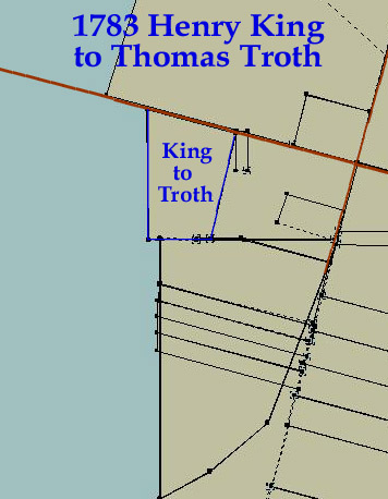
18 ER 189 - 19 December 1840 - Henry Page, trustee, to Anthony Manning for $100: By a decree of the chancery court 2 July 1839, Henry Page was appointed trustee to sell the real estate of Thomas Troth, deceased, for distribution among his legal representatives. On 3 August 1839, he sold to Anthony Manning, lot in East New Market which was purchased by Thomas Troth, deceased, of Henry King on 11 April 1783 called "Anderton's Desire". Beginning at a marked cedar post E 2 1/4 perches distant from the original bounder of "Anderton's Desire", and from thence runs N 13 E 16 1/2 perches to another cedar post at number 3, then N 75 W14 perches, then S 1 E 20 perches to a marked post standing on the first line of "Anderton's Desire", thence with a straight line to place of beginning. Containing in the whole 1 1/2 acres according to the deed in Liber 20 HD 345-346.
18 ER 187 - 19 December 1840 - Henry Page, trustee, to Anthony Manning for $113: By a decree of the chancery court 28 June 1839, Henry Page was appointed trustee and authorized to sell the real estate of William Roach, deceased, for the payment of his debts. On 25 June 1839, he did sell to Anthony Manning, all the deceased right to a lot in East New Market, which as originally purchased by Thomas Troth of Henry King on the 11 April 1783 called "Anderton's Desire". Beginning at a marked cedar post standing E 2 1/4 perches distant from the original bounder of "Anderton's Desire", and from thence runs the several causes and distances as described in a deed this day executed by Henry Page, trustee for the sale of Thomas Troth's real estate to Anthony Manning. Containing 1 1/2 acres of land.
Cambridge Chronicle - 1 February
1840 - Anthony Manning vs. Samuel Troth & others.
In Chancery 17 January 1840. The object of the bill filed in this cause
is to obtain a decree for the sale of the real estate of which Thomas
Troth died seized. The bill states that the said Thomas Troth left the
following heirs at law to wit: Nancy Troth, Henry Troth, Samuel Troth,
Robert Troth, & Sylvester Troth. That the undivided interests which
descended to the said Nancy, Robert, & Sylvester Troth have been
purchased by this complainant and are now owned by him. That Henry Troth
has died and left an only child who lives without the limits of this
state, and the name of the said child is not known to the complainant.
That the estate is too small to be divided without detriment to all
interested, and the Bill prays a sale of the said property by a decree
of this court.
It is therefore ordered that the complainant by causing a copy of this
order to be published in some newspaper once in each of three successive
weeks before the first day of March next, give notice to the legal
representatives and heirs at law of the said Henry Troth of the
substance and object of the Bill, that they be warned to appear in this
court in person or by solicitor on or before the 17th day of June next,
to show cause if any they have why a decree should not be passed as
prayed.
17 ER 396 - 3 September 1839 - Robert W. Troth and Sylvester H. Troth to Anthony Manning for $135: their right to house and lot in the town of East New Market which formerly belonged to Thomas Troth, deceased, their father, being 2/5 in fee simple subject to the dower interest of the late Thomas Troth's widow being the same lot purchased of Thomas Troth from Henry King on 11 April 1783 and called "Anderton's Desire". Beginning at a marked cedar post standing E 2 1/4 perches distant from the original bounder of "Anderton's Desire" and from thence runs N 12 E 16 1/2 perches, to another cedar post at number 3, then N 75 W 14, then S 1 E 20 perches to a marked post standing on the first line of "Anderton's Desire", thence with a straight line to the place of beginning. Containing 1 1/2 acres of land according to the actual measurement referenced to the said deed enrolled in 20 HD 343-346.
1838 Tax Assessment List
Thomas Troth's heirs call on William Roach $200 in real estate, $0 in
personal estate
11 ER 261 - 26 February 1829 - Henry Nicols to William Roach for $80: a house and lot in the village of New Market, formerly the property of Thomas Troth, deceased. Said lot or part thereof was deeded to said Henry Nicols by Solomon Jump & Nancy, his wife, and also all Samuel Troths' part of said lot vested in said Henry Nicols. Celia Nicols, wife of Henry Nicols.
10 ER 309 - 3 May 1826 - Solomon Jump & Nancy, his wife, to Henry Nicols for $80: house and lot which was formerly the property of Capt. Thomas Troth in New Market.
10 ER 171 - 22 November 1825 - Samuel H. Troth to Solomon Jump for $60: house & lot in New Market where Thomas Troth formerly lived, being the same property Thomas Troth bought of Henry King.
Republican Star - 20 August 1822
- Died -
In New Market, Dorchester County, on Monday 12th instant, Captain Thomas
Troth after a short illness.
20 HD 343 - 11 April 1783 (recorded 6 June 1803) - Henry King to Thomas Troth for $55: part of a tract called "Anderton's Desire" in the village of New Market. Beginning at a marked cedar post standing E 2 1/4 perches distance from the original boundary of "Anderton's Desire" and from thence runs N 13 E 16 1/2 perches to another cedar post at No. 3, then N 75 W 14 perches, then S 1 E 20 perches to a marked post standing on the 1st line of "Anderton's Desire", thence with a straight line to the place of beginning. Containing 1 1/2 acres. Amelia is wife of Henry King.
20 HD 398 - 25 October 1802 - Commission Certificate to Joseph
Ennalls, John Stevens, Joseph Whiteley, Edward Whiteley and William
Ennalls, gentlemen. Henry King petitions the court that a certain John
Anderton Mitchell died intestate and seized of lands in Dorchester
County. Your petitioner and a certain Mary King, sister of your
petitioner, of full age, and a certain Mary King the only child and
daughter of a certain Edward King, who was a brother of your petitioner
and is now dead, are entitled to the said lands by inheritance as heirs
at law and representatives of the said John Anderton Mitchell, deceased.
The Mary King, last aforesaid, is a minor. Your petitioner therefore
prayed that the said court will appoint a commission to divide the
lands. Notice was given to Betsy King who the court appointed as
guardian of the said Mary King, who is a minor under the age of 21
years. The Commission estimated the value of the land at 3618 pounds and
divided it.
---For Henry King, 3 parts valued at 1206 pounds:
(3) Beginning for the 3rd lot laid out for Henry King at a cedar post as
No. IV at O on the plot standing E 2 1/4 perches distance from the
original bounder of the land called "Anderton's Desire" and from thence
runs N 13 E 16 1/2 perches to another cedar post as No. III at P on the
plot, then N 75 W 14 perches, thence S 1 E 20 perches to an oak post
standing on the first line of "Anderton's Desire" and then with a
straight line to the beginning. Containing 1 1/2 acre. The oak post at
B.
1783 Tax Record
John Anderton
the following improvements were on the combined 350 acres:
1 brick dwelling, 1 brick kitchen, 1 brick quarter, 1 brick mill house,
2 frame barns, 5 logged houses, 1 little house, and 1 good garden &
orchard. In addition, he leased a small lot with 1 small old
framed house to William Trippe. The little house, 5 logged houses,
or Trippe's house could be this house.
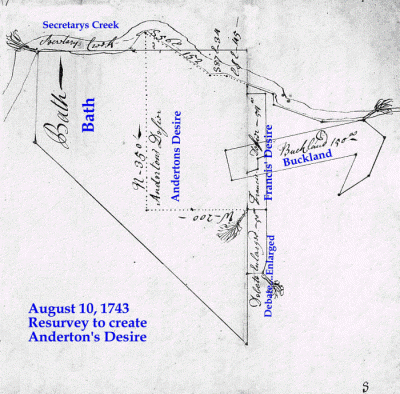
2 NH 403 - 8 December, 1782 - Whereas John Anderton by
his humble petition prays a Commission to perpetuate the boundaries of
his lands called "Debate Enlarged" and part of "Westward". Commission
appointed. James Sulivane enters himself as defendant...
(4) Deposition of John Hutchinson, aged about 26 years - , saith about 6
years ago, he carried the chain for Mr. James Sulivane under Mr. William
Davis, surveyor. with Nathan Bradley. He says he cannot remember where
the bounder was nor how it was. He believes he run a north course where
the beginning was. He believes the beginning was near this place. He
remembers running near the house where William
Troth now lives.
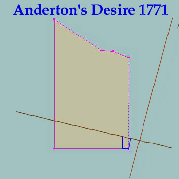
25 Old 9 - 13 June 1771 - Francis Anderton, planter, to John Anderton, merchant, for 10 pounds and a tract called "Sandwich" in the forks of Cabin Creek's branches: (1) A tract called "Anderton's Desire". Beginning at a marked Spanish oak, being the same tree that is specified in his deed of part of "Bath" that old Francis Anderton, deceased, purchased of Taylor, then runs W 200p, then N 350p, to the branch, then S56E 152p bounded with the branch, then S87E 34p bounded as aforesaid, then ESE 45p, bounded as aforesaid, then with a straight line to the first beginning. Containing 354 acres.
35 XYZ? 344 - Will of John Anderton - 22 July 1760 / 10 April 1767 -
Land to be divided between sons John Anderton and Francis Anderton.
One slave to daughter, Sarah Anderton. I have already given
daughter, Betty King, part of personal estate. Desire that what
she had already received shall be in part of her portion.
Executor: son, John. Witn: Daniel Sullivane Jr. &
Sarah Sullivane, Catharine Cannon.
Codicil: 8 January 1761 - to son-in-law Robert Clarkson, one
slave. Witn: Daniel Sullivane, Henry Trippe.
9 Old 138 - 11 June 1731 / 22 January 1732 - Commission to perpetuate the bounds of Henry Tripp's land called "Bath" and return. Bounder proved in the presence of Thomas Ennalls of Chickanacomaco, Bartholomew Ennalls of Choptank, Joseph Nicolls, Peter Taylor Junr., and Isaac Nicolls. Deposition of Peter Taylor aged about 52 years regarding bounder of said land on north side of the easternmost branch of Secretary Creek, identified to deponent about 35 years ago by Thomas Pattison who had surveyed the land for the deponent's father, Major Thomas Taylor. Deposition of John Anderton aged about 39 years regarding bounder shown to him about 26 years ago by his father, Francis Anderton, on the north side of the easternmost branch of Secretaries Creek and a little below the fork; the said land being owned at that time by Charles Rye - and Francis Anderton and others owning the adjoining lands.
Liber 13, Folio 697 - Will of Francis Anderton - 7 December 1713 / 10
March 1714
To eldest son, John - 295 acre part of "Bath" and a 50 acre part of
"Westward" including dwelling plantation at
decease of wife.
To son, Francis and heirs - 200 acre "York" and 50 acre part of
"Westward"
To wife, Mary, executor, life interest in lands devised to son John, and
personal estate for maintenance of two daughters, Mary and Sarah.
Test: Abigail Ricks, John Ricks, John Kicke, Edmund Mackel
[It is not clear from this Will abstract if the
dwelling plantation left to John Anderton was on the 295 acre part of
the tract "Bath" or the lower 50 acres of "Westward". We need to
review the original document for a better determination.
This part of the 295 acre tract called Bath was northwest of the center
of East New Market and not abutting the main roads. The house
known as Rose Hill was likely on this 295 acre part of Bath. This
tract will be researched in the near future. The house known as
Buckland is on the 50 acre part of Westward, but it is not known if it
was at this location as early as 1713.]