East New Market
Property Reports
39 Main Street
John B. Leckie & Son
John L. Willis & Co.
Key date analysis:
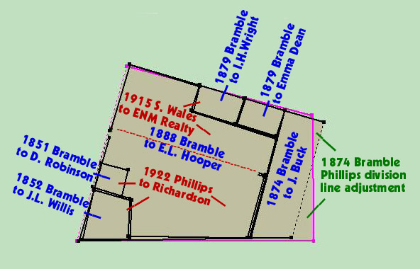
In 1851, Mary Bramble began to sell pieces of the lot she owned at the southeast corner of Main Street and Railroad Avenue. John L. Willis purchased a small part of this property in 1852. The 1863 Tax Assessment List shows John L. Willis & Co. with $1000 in goods. He was likely operating a store from this location. In 1859, John L. Willis was first taxed for a store house. He may have built the storehouse at that time. John Q. Leckie purchased the store house and lot in 1861. An 1887 newspaper article about a major fire in East New Market indicates a fire started in the store owned by Mrs. S.H. Leckie. At the time the store was being run by C.C. Hubbard. This fire also destroyed the William Hooper Store.
The lots where the stores of John B. Leckie & Son and William Hooper stood became the site of the two-story wooden J. Millenson & Son store. This store was destroyed in the 1914 fire. The 1922 Sanborn Map shows the property as an empty lot. By the late 1920s, a new structure was built and used as a gas station. The structure was later converted to a restaurant and bar. The property is now known as Johnny's Tavern.
Who built it:
John L. Willis likely built the store as early as 1852 or as late as 1859.
Longest Residents:
The Leckie family operated a store at this location for about 16 years.
More Research:
Historic Records:
173 PLC 115 - 9 March 1972 - Charles C. Powell to John S. Warner & Margaret A. Warner, his wife, for $5: lot in the town of East New Market on the east side of Main Street, bounded on the north by the property of the Masonic Lodge, on the east by the property now or formerly owned by Dorsey & Mary Webster, and on the south by the property of the Choptank Distributing Company, Inc. Beginning on the eastward side of Main Street distant 66 feet from the southeastward corner of said Main Street and Railroad Avenue, and from thence runs and binds S73/40E 158.6f with the northward side of an alley 12 foot in width to a stone, thence S15/10W 62.25f to a stone, thence S89W 165.3f to the eastward side of Main Street, thence running and binding with said Main Street N16/10E 105.25f to the place of beginning. Saving and excepting land conveyed unto the Choptank Distributing Company, Inc. by deed dated 15 October 1964 in 140 PLC 112, subject to an easement granted unto J. Edward Powell on 31 January 1968 in 154 PLC 527. Being part of the land conveyed unto the said Charles C. Powell by deed dated 6 November 1963 in 136 PLC 15.
140 PLC 112 - 15 October 1964 - Charles C. Powell & Beverly F. Powell, his wife to Choptank Distributing Company, Inc. for $5: lot being a part of all the land conveyed unto the said Charles C. Powell from Charles E. Edmondson, Assignee of Mortgage; beginning at a stone set at the end of the 2nd line which by deed dated 6 November 1963, 136 PLC 15 was conveyed by Charles E. Edmondson, Assignee of Mortgage, to Charles C. Powell, thence running reversely on said 2nd line and on a part of the 1st line of said deed as not surveyed, etc.
136 PLC 15 - 6 November 1963 - Charles E. Edmondson for the purpose of foreclosure, to Charles C. Powell for $4600: Whereas at a public sale on 10 September 1963 pursuant to the special authority vested in him as Assignee of Mortgage for the purpose of foreclosure in a mortgage from George W. Weber Jr. & Ann E Weber, his wife, unto Charles C. Powell dated 28 September 1962 in 127 PLC 1 which mortgage was assigned to Charles E. Edmondson for the purpose of foreclosure. Sold per No. 9446 Chancery. Lot in the town of East New Market on the eastward side of Main Street and bounded on the north by the property of the Masonic Lodge, on the East by the property of Darcy & Mary Webster, and on the south by the property of Iva Collins. Beginning on the eastward side of Main Street distant 66 feet from the southeastward corner of said Main Street and Railroad Avenue, and from thence runs S73/40E 158.5f with the northward side of an alley 12 foot in width to a stone, thence S15/10W 62.25f to a stone, thence S89W 165.3f to the eastward side of Main Street, thence running with said Main Street N16/10E 105.25f to the place of beginning. And in consideration aforesaid, the said Charles E. Edmondson, Assignee of Mortgage does hereby convey unto the said Charles C. Powell the following personal property - one 18 foot service bar, 9 bar stools, 2-3 basin sinks, gas hot water heater, 10 foot soda fountain 8 hole 6 dispenser, 5 digit National Cash Register, 5 foot candy case, 5 foot 2 door dairy case, and such other personal property located in the building upon the land above. Being the same land conveyed unto George W. Weber Jr. by deed from Minnie L. Mowbray, unmarried, and Marguerite E. Kelley, unmarried, dated 28 September 1962 in 129 PLC 534.
129 PLC 534 - 28 September 1962 - Minnie L. Mowbray and Marguerite E. Kelley, both single, to George W. Weber Jr. for $3000: Also sold personal property for $1000. [Described in 136 PLC 15]. Being the same property conveyed to Minnie L. Mowbray and Marguerite E. Kelley by Julian M. Richardson 7 Frieda Richardson, his wife, by deed dated 8 December 1959 in 117 PLC 217.
117 PLC 217 - 8 December 1959 - Julian M. Richardson & Frieda Richardson, his wife, to Minnie L. Mowbray and Marguerite E. Kelley for $5: [Described in 136 PLC 15]. Same property conveyed to Julian M. Richardson by Edward S. Phillips & wife by deed dated 2 January 1922 in 11 JFD 170.
11 JFD 170 - 2 January 1922 - Edward S. Phillips & Mary V. Phillips, his wife, and the Eastern Shore Trust Company to Julian M. Richardson for $5: Whereas Edward S. Phillips & Mary V. Phillips, his wife, executed a mortgage to the Eastern Shore Trust Company dated 27 August 1921 in 11 WHM 154. Lot in East New Market. Beginning on the eastward side of Main Street distant 66 feet from the southeastward corner of said Main Street and Railroad Avenue, from thence runs and binds S73/40E 158f with the northward of a alley 12 feet in width to a stone, thence S15/10W 62.25f to a stone, S89W 165.3f to the eastward side of Main Street, thence running with Main Street N16/10E 105.25 to the place of beginning. Being the same land which is designated as "Lot number 1" in a deed to the said Edward S. Phillips from Minnie R. Hooper & husband, dated 14 June 1921 in 10 WHM 373.
11 WHM 154 - 27 August 1921 - Mortgage - Edward S. Phillips & Mary V. Phillips, his wife, owing to the Eastern Shore Trust Company for $6000, which has been paid unto Frederick H. Fletcher and J. Richard Jones, assignees of Mortgage: A lot in Cambridge and a lot in East New Market. Beginning on the eastward side of Main Street distant 66 feet from the southeastward corner of said Main Street and Railroad Avenue, from thence runs and binds S73/40E 158f with the northward of a alley 12 feet in width to a stone, thence S15/10W 62.25f to a stone, S89W 165.3f to the eastward side of Main Street, thence running with Main Street N16/10E 105.25 to the place of beginning.
10 WHM 373 - 14 June 1921 - Minnie R. Hooper & Edward L. Hooper, her husband, to Edward S. Phillips for $5: Lot Number 1. Beginning on the eastward side of Main Street distant 66 feet from the southeastward corner of said Main Street and Railroad Avenue, from thence runs and binds S73/40E 158f with the northward of a alley 12 feet in width to a stone, thence S15/10W 62.25f to a stone, S89W 165.3f to the eastward side of Main Street, thence running with Main Street N16/10E 105.25 to the place of beginning. The above described lot is composed, in part, of the three following pieces of land conveyed by Susan J. Wales by the following deed from the grantors therein named as follows (a) from Edward L. Hooper & Minnie R. Hooper, his wife, dated 10 May 1889 in 12 CL 594; (b) from the said Edward L. Hooper & Minnie R. Hooper, his wife, dated 9 May 1893 in 17 CL 403, and (c) from John Gould Francis Leckie & Blanche H. Leckie, his wife, dated 8 December 1902 in 27 CL 337. Said lots were devised unto the said Minnie R. Hooper, wife of the said Edward L. Hooper, by the last will and testament of her mother, Susan J. Wales in 2 RPS 89, reserving however to the East New Market Realty Company, the easement over an alley described in a deed dated 25 May 1915 in 9 WLR 39.
[Susan J. Wales had previously purchased two other lots to the north including the William Hooper/Millenson Store lot, and the Chesadale Hotel.]
27 CL 337 - 8 December 1902 - John Gould Francis Leckie & Blanche H. Leckie, his wife, of Baltimore, to Susan J. Wales for $125: Whereas by the second item of the last will and testament of John Q. Leckie, deceased, in 2 EWL 103, the lands hereinafter described among other lands, were devised unto his wife Sarah P. Leckie during her life or widowhood, with remainder over to his two sons, Andrew Leckie and John Gould Francis Leckie. Whereas the said Sarah P. Leckie and Andrew Leckie did by deed dated 6 March 1899 in 24 CL 440 convey all their interest in the hereinafter described property unto the said John Gould Francis Leckie. Whereas the said John Q. Leckie left another son, surviving him, Thomas Leckie, and a doubt having arisen whether the said Thomas Leckie would take any interest in said property as an heir at law, in 2505 Chancery , the court decided to give the entire interest unto Andrew Leckie and John Gould Francis Leckie upon the death or remarriage of Sarah P. Leckie. Beginning at a point whereupon stood the corner of a store house in the year 1861, which prior to that time was occupied by Edward E. Medford, and on the west line of a tract called "New Market" to a point whereon stood a post at the last named date, thence 38 feet parallel with said street, thence 38 feet to the street aforesaid, and thence with said street 49 1/2 feet to the place of beginning
24 CL 440 - 6 March 1899 - Sarah P. Leckie, Thomas Leckie & Annie E.
Leckie, his wife, of Dorchester County, and Andrew Leckie of Baltimore
City to John Gould Francis Leckie: Whereas by the last Will and
Testament of John Q. Leckie, deceased, the lands hereinafter described
and conveyed were devised unto the said Sarah P. Leckie, during her
natural life or widowhood, but in the event of her marriage the said
land or property was to be divided between the two youngest sons of the
testator, the said Andrew Leckie and John Gould Francis Leckie in equal
portion. And whereas the said John Q. Leckie departed this life
leaving another son by a former marriage, the said Thomas Leckie,
surviving him and whereas some question having arisen as to the
respective right of the said sons of the testator, Thomas, Andrew, and
John Gould Francis, in the estate of their father, including the lands
hereinafter described, an agreement was entered by the said Thomas,
Andrew, and John Gould Francis, and Sarah P. Leckie, which said
agreement is not on file in the Circuit Court - Freeland Hall & Co. vs.
Thomas Leckie & others, No. 1043 Chancery.
First - all that lot beginning at a corner of a store house standing in
the year 1861 and prior to that time occupied by one Edwin E. Medford,
on the east side of the Main Street in the town of East New Market, and
on the west line of a tract called "New Market", thence running with
said line 47 1/3 feet to a post standing at the last named date, thence
38 feet parallel with said street, thence 38 feet to the street
aforesaid, and from thence with said Street the distance of 49 1/2 feet
to the place of beginning. Being the same land described in a deed
dated 4 September 1861 in 5 FJH 110 from John L. Willis & wife to
John Q. Leckie.
1896-1910 Tax Record
Mrs. Sarah P. Leckie
1 lot between the S.E. Collins & the Hooper property
1896 Tax
Record
Mrs. Sarah P. Leckie
1 lot between the S.E. Collins & the Hooper property $100
Baltimore Sun - 9 December 1887
- Fire at East New Market -
East New Market, Dorchester Co., Md, Dec 8. - A fire originated this
morning about half-past four o'clock in the store of C.C. Hubbard, on
Main Street, and quickly spread to the adjacent
building, owned by W.R. Hooper and M.S. Fletcher, which were
entirely destroyed. The alarm was given by some parties who discovered
the fire, and the citizens quickly responded and rendered timely aid in
saving adjoining property. Had the wind been blowing at even a moderate
rate the entire business part of the town would have been consumed. The
seeming danger of the town was sufficient cause for serious
apprehensions, as buckets were the only means to be employed to
extinguish the flames, as there is no fire extinguishing apparatus
belonging to the town. The buildings owned by S.E. Collins and W.R.
Sherman and the Bramble House narrowly escaped, and the feat performed
in extinguishing the fire with such inadequate means was remarkable.
The storehouse where the fire originated was owned by Mrs. S.H. Leckie,
and is valued at $900, insured for $610. C.C. Hubbard places his loss
on his stock of general merchandise at $2,000, insurance $1,500. W.R.
Hooper's loss will reach about $700, insurance $600. M.S. Fletcher's
loss is $800, uninsured. It is generally conceded that the fire was of
an incendiary origin.
1876 Tax
Record
Thomas Leckie, acting admin for J.Q. Leckie, deceased
Store house in ENM - $500
1867-1876 Tax Record
John Q. Leckie
1867 - Store House & Lot $600
1866 Tax
Record
John Q. Leckie
Store house & lot $600
Cambridge Herald - 11 September
1861
Dr. Swayne's Compound Syrup of Wild Cherry - Dr. Swayne & Son,
Philadelphia. "Sold at the office of the Cambridge Herald", also by W.M.
Thomas, Cambridge, J.B. Leckie & Son, New Market, W.J. Vane, Hicksburg,
and by dealers in medicine everywhere.
5 FJH 110 - 4 September 1861 - John L. Willis & Susan L. Willis, his wife, of Caroline County, to John Q. Leckie for $462.50: Beginning at the corner of the store house formerly occupied by Edwin E. Medford on the east side of the main street in the town of East New Market and on the west line of a tract called New Market, thence running with said line 47 1/3 feet to a post, thence 38 feet parallel with said street thence 38 feet to the street aforesaid and from thence with said street the distance of 49 1/2 feet to the place of beginning. Being the same land John L. Willis obtained from Mary Bramble by deed dated 6 October 1852 in 2 FJH 129.
July 1853 Tax
Assessment List
John L. Willis & Co.
Real Estate $0, Personal Estate $1000
John L. Willis
Real Estate $100, Personal Estate $1869
1852-1864 Tax Record
John Q. Leckie
House & Lot from J.L. Willis $500
John L. Willis
1853 lot of land from Mary Brown (Bramble) $400
1859 Store House in New Market $500
.....reduced
1862 by house & lot sold to J.Q. Leckie
2 FJH 129 - 6 October 1852 - Mary Bramble to John L. Willis for $150: lot called New Market situated in the town of East New Market on the east side of the main street. Beginning at the corner of the store house occupied by Edwin E. Medford on said main street (the east side thereof) it being the west line of the a tract of land called New Market with said line the distance of 47 1/3 feet to a post, from thence 38 feet parallel with said street, thence 38 feet to the street aforesaid and from thence with said street the distance of 49 1/2 feet to the place of beginning.
1851 Dorchester County Directory (East New Market entries)
General Dealers in Dry Goods, Groceries, Hardware, &c.
John B. Leckie & Son
Marriage - 27 November 1850 - John L. Willis to Susan L. Stewart
Cambridge Chronicle – 10 June
1848 – Marriage –
Married on Tuesday evening last by Rev. M.D. Kurtz - John Quincy Leckie
to Miss Rebecca Ann, daughter of Algernon Thomas, all of this county.
Marriage - 18 March 1817 - Jeremiah Bramble to Mary King
3 ER 355 - 23 March 1814 - Mary King, orphan, by her guardian James
Twilly, humbly sheweth that Mary King, deceased, died intestate since
the 1st of January 1788, seized of certain tracts of land leaving the
following hiers to wit, Sarah King, Amelia King, Elizabeth King, and
Harriet King, daughters and heirs of Henry King, and Mary King, the
petitioner, daughter & the heir of Edward King. The petitioner
prays for your honor to appoint a commission to divide the land.
The court have appointed James Twilley guardian to Mary King, and Amelia
King guardian to Sarah King, Elizabeth King, Amelia King, and Harriet
King, being infants under the age of twenty-one years. The
commission to divide the land appointed - Levin Marshall, Henry Haskins,
Joseph Whitely, Thomas Ennalls, and Henry Hicks (of D.). They took
oath. They divided part of a tract called "Anderton's Desire" that
was laid off for Mary King, sister of Henry King in a commission granted
Henry King in 1803 for 71 acres and in order to divided the same into 2
divisions equal in quantity and quality.
Secondly, Laid off for Mary King, daughter and heir of Edward King the
following lots, value of $1971.50.
Lot No. 2 - The yellow house lot in New Market. Beginning at an oak post
marked TM at letter G on the plat and on the first line of the land sold
Anderton by Rix and close to the East side of the main street and runs E
14 1/2 perches to the end of said first line, then N1W 7 1/2 perches to
the main road that leads from Crothers Ferry to New Market then with
said road N 75 W 11 perches & 6 feet to the main road from Cabin Creek
to Cambridge and then with said road to the place of beginning.
Containing 3/4 of an acre.
[When Mary King, sister of Henry King died, the land was given to their niece, Mary King. She was the daughter of Henry King's brother Edward.]
20 HD 398 - 25 October 1802 - Commission Certificate to Joseph
Ennalls, John Stevens, Joseph Whiteley, Edward Whiteley and William
Ennalls, gentlemen. Henry King petitions the court that a certain John
Anderton Mitchell died intestate and seized of lands in Dorchester
County. Your petitioner and a certain Mary King, sister of your
petitioner, of full age, and a certain Mary King the only child and
daughter of a certain Edward King, who was a brother of your petitioner
and is now dead, are entitled to the said lands by inheritance as heirs
at law and representatives of the said John Anderton Mitchell, deceased.
The Mary King, last aforesaid, is a minor. Your petitioner therefore
prayed that the said court will appoint a commission to divide the
lands. Notice was given to Betsy King who the court appointed as
guardian of the said Mary King, who is a minor under the age of 21
years. The Commission estimated the value of the land at 3618
pounds and divided it.
---For Mary King, sister of Henry King, land valued at 1206 pounds:
(2) Beginning at an old oak post marked TM at T on the plot and on the
first line of the land that John Rix sold to John Anderton and close on
the east side of the main street and there runs E 14 perches to a cedar
post at the end of said first line of the land from Rix to Anderton as
No. 1 at N on the plot, then N 1 W 7 1/2 perches to the main road that
leads from Crotcher's Ferry to New Market, then bounded by said road N
75 W 11 perches and 6 feet to the main road that leads from Cabin Creek
to Cambridge and then with said road to the place of beginning.
Containing 3/4 acres & 3 square perches.
[Mary King, sister of Henry King was given the south east 3/4 acre of her brother's 50 acre lot]
25 Old 9 - 13 June 1771 - Francis Anderton, planter, to John Anderton, merchant, for 10 pounds and a tract called "Sandwich" in the forks of Cabin Creek's branches: (3) Also part of a tract called "Buckland" and part of a tract called "Debate Enlarged", being the land granted by a certain John Rix to the aforesaid John Anderton, deceased. Beginning at the end of 6p in an E course drawn from a marked live oak standing in the edge of a swamp in the fork of Secretary's Creek, being the beginning tree of said John Anderton, deceased, his part of a tract called "Bath", then runs still E 32p, then N 172 1/2p, then E 3p, then N to the branch, then binding with the branch until it intersects a N course from the beginning. Containing 50 acres. John Anderton, deceased, is the father of said Francis Anderton.
11 Old 200 - 29 June 1743 - John Rix to John Anderton in consideration of 50 acres of land lying in the fork of Secretary's Creek being a part of a tract of land called "Westward" as by deed bearing equal date with there presents may more fully appear: land being a part of "Buckland" and part of "Debate Enlarged". Beginning at the end of 6p in an east course drawn from a marked live oak standing in in the leg of a swamp in the fork of Secretarys Creek, being the beginning of said Andertons part of a tract Bath, then runs still East 32p, then N 172 1/2p, then E 3p, then N to the branch, then binding with the branch until it intersects a north course from the beginning. Containing 50 acres.