East New Market
Property Reports
14 Railroad Avenue
Buckland
(Also known as Maurice Hall, Maurice Manor, Alice Webster House, and Westward)
Key date analysis:
A deed from 1745 and a deed from 1748 for adjacent properties mention a dwelling on this property. A 1743 deed for this property mentions "houses" which may be standard wording or may mean a house was on this property when it was sold to John Rix in 1743. The Will of John Rix also appears to place a house on this tract in 1748.
Who built it:
Architectural Historians have dated the construction of the house to the mid-1700s.
Longest Residents:
Daniel Sulivane lived here about 37 years, Margaret Maurice owned the house for 30 years.
More Research:
The 1713 Abstract of Francis Anderton's Will mentions a dwelling on land he left to his eldest son John. Need to examine the original Will to determine if this dwelling was on a part of the tract "Bath" northwest of town or whether it was this property on the lower half of the "Westward" tract. The 1748 Will abstract for John Rix also mentions a dwelling plantation. This Will also needs to be researched. Dendrochronology could also establish the construction date of various sections of the house.
Historic Records:
231 PLC 767 - 27 August 1984 - T.R. Trimble Co. Inc. to Raleigh Cline & Caroline S. Cline for $93,000: Being the same property described in 22 PLC 534.
220 PLC 534 - 21 October 1981 - Harold Bishop Gensler, representative for the estate of John P. Burton, deceased, of the town of Blue Bell, Pennsylvania to T.R. Trimble Co. Inc. for $19,000: Whereas by deed dated 15 July 1980 in 215 PLC 469, Lois M. Leary did seek to convey unto John P. Burton the property described, however said deed failed to convey the interest of the said Lois M. Leary, and therefore the grantor does enter into this deed to convey all of her right, title, & interest. Whereas John P. Burton departed this life on 14 February 1981, testate, and by his Last Will and Testament appointed Harold Bishop Gensler as his personal representative: Lot in the town of East New Market on the north side of Railroad Avenue, bounded on the north by the lands formerly owned by John A. Baker, now deceased, and the lands owned or formerly owned by Everett Holland, on the west by the lands owned of formerly owned by said John A. Baker, on the south by said Railroad Avenue, and on the east by Cleveland Street. Being the same land conveyed unto Lois M. Leary from Hilda C. McGuigan by deed dated 8 October 1954 in 91 RSM 34 and also being the same property which Lois M. Leary did attempt to convey unto John P. Burton by the aforesaid deed dated 15 July 1980 in 215 PLC 469.
215 PLC 469 - 15 July 1980 - Lois M. Leary to John P. Burton:
91 RSM 34 - 8 October 1954 - Hilda C. McGuigan of Baltimore to Lois M. Leary for $5: Lot which was conveyed unto the said Hilda C. McGuigan by Margaret M. Livsey & Donald M. Livsey, her husband, by deed dated 27 September 1947 in 64 RSM 172. [same description as 220 PLC 534].
64 RSM 172 - 27 September 1947 - Margaret M. Livsey & Donald M. Livsey, her husband, of Richmond to Hilda C. McGuigan of Baltimore for $5: Being the same land conveyed to Margaret M. Livsey by Margaret L. Maurice (widow) by deed dated 13 April 1943 in 47 RSM 25. [same description as 220 PLC 534]
47 RSM 25 - 13 April 1943 - Margaret L. Maurice, widow, to her daughter, Margaret M. Livsey of New York City for love & affection: same land conveyed by deed from Samuel J.T. Smith & Mary R. Smith, his wife, on 1 September 1913 in 6 WLR 415. [same description as 220 PLC 534]
1930 Census
undetermined
1920 Census
undetermined
6 WLR 415 - 1 September 1913 - Samuel J.T. Smith & Mary R. Smith, his wife, to Margaret L. Maurice, wife of Louis Maurice of New York City for $1600: all that dwelling house property in East New Market on the north side of Railroad Avenue, bounded on the north by the lands of John A. Baker and Everett Holland, on the west by the lands of the said John A. Baker, on the south by said Railroad Avenue, and on the east by Cleveland Street. Being the same property conveyed unto Samuel J.T. Smith by Henry McWilliams & wife by deed dated 6 January 1911 in 3 WLR 45. Reserving the right unto the said Samuel J.T. Smith to remove at any time before 1 January 1914, the new barn now on said premises, built by the said Samuel J.T. Smith.
3 WLR 45 - 6 January 1911 - Henry A. McWilliams & Emma T. McWilliams, his wife, of Sharpton, MD to Samuel J.T. Smith for $1200: all that dwelling house property in East New Market on the north side of Railroad Avenue, bounded on the north by the lands of John A. Baker, on the west by the lands of the said John A. Baker, on the south by said Railroad Avenue, and on the east by Cleveland Street. Being the same property conveyed unto Henry A. McWilliams by Ida R. Bramble and others by deed dated 31 January 1907 in 32 CL 660
1910 Census
Possibly dwelling #35, household of J. Harry Howard, merchant at retail
grocery
32 CL 660 - 31 January 1907 - Ida R. Bramble of Baltimore, William M. Fletcher, and John W. Fletcher, trustees to Henry A. McWilliams for $875: Whereas by deed of trust 28 August 1889 in 13 CL 3 Major S. Fletcher & Willie K. Fletcher, his wife, conveyed unto said William M. Fletcher and John W. Fletcher, trustees, the hereinafter mentioned property, with power to sell the same for the benefit of the creditors of the said Major S. Fletcher did on 28 June 1890 sell to the said Ida R. Bramble. Being the same land intended to be conveyed to Ida R. Bramble by William M. Fletcher and John W. Fletcher, trustees, by deed dated 26 June 1897 in 21 CL 518. (Her middle initial was wrong in deed) Part of Lot No. 6.
1900 Census
Dwelling #269, household of Joseph Henry, druggist, & Ida Bramble,
retired school teacher
1896-1910 Tax Record
Miss Ida Bramble
1896- Lot in ENM on north side of Railroad Ave. 120x300 feet $200
Dwelling house $800
5 January 1909 - Insolvent
1896 Tax
Record
Miss Ida Bramble
1 lot in East New Market on the north side of Railroad Avenue 120x300
$200
Dwelling house $800
13 CL 3 - 28 August 1889 - Major S. Fletcher & Willie K. Fletcher, his wife, to John W. Fletcher and William M. Fletcher: In trust for the benefit of his creditors property consisting of the premises, household furniture in the dwelling house, now occupied by the grantors, the crops on lot in East New Market, 1 horse, 1 cow, 2 hogs, 1 carriage, 1 wagon, and 1 cart. 5 lots not in ENM. (6) Lot No 6 - All that tract on the right hand side of the street leading from the Rail Road Depot at East New Market to the village of East New Market. Being the same lands conveyed unto Major S. Fletcher by William Christopher and wife by deed dated 1 January 1864 in 5 FJH 497 also by deed from William Christopher 1 April 1867 in 7 FJH 32, together with all the buildings and other improvements including the dwelling house and appurtenant buildings formerly occupied by the said Major S. Fletcher as a residence. And also the new store house at or near the railroad depot and as well all other buildings and improvements on said lands.
10 CL 736 - 31 March 1888 - Mortgage - Major S. Fletcher owing to William M. Fletcher and John W. Fletcher: Whereas William M. Fletcher and John W. Fletcher have endorsed several promissory notes of the said Major S. Fletcher of various amounts aggregating a sum between $5000 and $10000 and where the said Major S. Fletcher wishes to secure the said William M. and John W. Fletcher against any loss that may occur: Tract on the right hand side of county road leading from the Rail Road Depot at East New Market to the village of East New Market. Being the same land which was conveyed unto the said Major S. Fletcher by William Christopher and wife by deed dated 1 January 1864 in 5 FJH 497. Also by deed from William Christopher dated 1 April 1867 in 7 FJH 32. Including the dwelling house and appurtenant buildings formerly occupied by the said Major S. Fletcher as a residence and also the new store house at or near the Rail Road Depot, and as well all other buildings. And also all that lot in the town of East New Market on the west side of the Main Street and on the south side of the street leading to the Episcopal Church, together with the dwelling house, store house, and all appurtenant buildings thereon. Being the same premises upon which the said Major S. Fletcher now resides. and the same lot of ground conveyed to the said Major S. Fletcher by Mary A. Bramble by deed dated 31 July 1862 in 5 FJH 220. Also those two lots of ground in the town of East New Market near the Methodist Church and adjoining the lot of William R. Hooper and the farm belonging to Thomas J. Hicks, deceased. Said lots being improved by two dwelling houses and other outbuildings and the same property formerly belonging to James Davis.
1880 Census
Dwelling #1, household of Joseph K. Bramble, magistrate
1876 Tax
Record
Major S. Fletcher
Buildings, Store House & Dwelling he lives in ENM - $6000
Dwelling house where G.W. Carroll lives in ENM - $1500
Vacant lot between ENM & depot 33 acres - $1650
1870 Census
Dwelling #348, household of Major Fletcher, retail merchant
1867-1876 Tax Record
William Christopher
1867 - House & Lot 7 acres - House and lot 7 acres $2000
reduced
1867 - House & Lot 7 acres to Major S. Fletcher $2000
Major S. Fletcher
1867 - House & Lot 7 acres from William Christopher $2000
7 FJH 32 - 1 April 1867 - Williiam Christopher to Major S. Fletcher for $2000: land and houses thereon. All the remainder of the land said William Christopher bought of James Gore, formerly owned and known as the Harry Nicols property and bounded on the north by the land of John Webster and on the south by the county road running from East New Market to Vienna. Containing 8 acres. All of the remainder of the tract of which Major S. Fletcher bought of said Christopher.
1866 Tax
Record
William Christopher
House & Lot $2000
5 FJH 497 - 1 January 1864 - William Christopher & Delia, his wife, to Major S. Fletcher for $1100: lot in East New Market. Beginning at the south end of a lane purchased by George W. Hicks, deceased, of James Gore binding with said lane until it intersects the lands belonging to the heirs of James Hicks, binding with said lands until it comes to the land of John Webster, binding with said lands until it comes to a post on the division line between John Webster and William Christopher, from said post to another post planted on the county road leading from East New Market to Vienna, binding with said road to the place of beginning. Containing whatever number of acres it may.
1860 Census
Dwelling #731, household of William Christopher, farmer
4 FJH 361 - 26 January 1859 - James Gore & Susan Gore, his wife, to William Christopher for $4100: part of a tract situated and adjoining the town of East New Market on the north side of the county road leading from the said town to Crotcher's Ferry, being the same land & premises that was conveyed by Kendal M. Jacobs and wife to the said James Gore on 17 December 1857 in FJH 4/117 excepting a recently new made lane that passes through the said land with its present length and breadth, for the use and benefit of George W. Hicks for a full compensation for the said lane, the said George W. Hicks gives in exchange a piece of land included and enclosed in the above bargained and sold part of a tract.
4 FJH 117 - 21 December 1857 - Kendall M. Jacobs, and Janett Jacobs, his wife, to James Gore for $4100: Farm where the said Jacobs now lives situated in East New Market on the north side of the main road leading to Crotcher's Ferry and conveyed to said Jacobs by a deed from Septimus Thompson and Sarah L. Thompson, his wife, and is recorded 5 WJ 166. Also a lot of ground deeded by Thomas K. Smith and enclosed with the above described parcel of ground.
American Eagle - 10 December 1856
– Married –
On Monday by Rev. Mr. Kemp - Mr. James M. Murphy of Queen Annes County
to Miss Mary E. Jacobs, only daughter of Kendall M. Jacobs of this
county.
1852-1864 Tax Record
Major S. Fletcher
1 lot in New Market of Wm Christopher & wife $1110
William Christopher (in District 2 w/ ENM property)
1859 land from James Gore 50 acres $2000
also a lot charged to K.M. Jacobs $100
.....reduced
1860 by a lot of land from Jacobs
1864 by a lot sold to M.S. Fletcher
James Gore
1858 House & Lot 50 acres in New Market of K.M. Jacobs $2000
.....reduced
1859 by land sold to Wm Christopher $2000
Kendal M. Jacobs
House & Lot 50 acres $2000
1855 unimproved lot in New Market $100
.....reduced
1858
by house & lot 50 acres in East New Market to James Gore $2000
1859 by unimproved lot charged to W. Christopher $100
1850 Census
Dwelling #406, household of Kendle M. Jacobs, farmer
5 WJ 166 - 1 October 1849 - Septimus Thompson & Sarah L. Thompson, his wife, of Baltimore to Kendal M. Jacobs for $2000: lot in and near the town of East New Market where a certain Thomas Willoughby now resides. Being the same property which belonged to a certain Henry Nicols, whereon he resided at the time of his death and which he devised to his wife during her natural life and after her death to a certain Emily E. Green and the said Emily E. Green having departed this life intestate, the said property has descended to the said Sarah L Thompson, her only sister of whole blood. Containing 50 acres
Cambridge Chronicle - 2 June 1849
– School Commissioners –
Appointment of school commissioners - District #2 - James Thompson,
Kendall M. Jacobs, Edwin E. Medford, William Mowbray, James N. Sherman.
1838 New Market District Tax
Assessment List
Henry Nicols heirs
$521 in real estate, $0 in personal estate
Emmilly C Green
$100 in real estate, $0 in personal estate
Marriage Records - 13 December 1832 - William Christopher to Delia Stevens
Cambridge Chronicle – 24 March
1832 – Died –
At his late residence in New Market, on Tuesday morning 20th inst., Mr.
Henry Nicols, aged about 53 years.
1 THH 27 - 15 March 1832 / 26 March 1832 - Will of Henry Nicols - Bequeaths to: 1. Margaret A. Nicols, wife, land where testator's dwelling house stands, purchased of Elizabeth Birckhead. 47 acres 2. Emily A. Green, daughter of Nathaniel A. Green, lot between the Methodist Church and the lots formerly belonging to Thomas Troth, the graveyard excepted. Lots were purchased from Henry Hicks and the Kings. And to have house and lot left to his widow, after her decease....
Cambridge Chronicle - 7 May 1831
- Married -
In this county, on Tuesday evening last by the Rev. Mr. Rauleigh, Mr.
Henry Nicols to Miss Margaret Ann Green.
Marriage Record - 29 April 1831 - Henry Nicols to Margaret Ann Bell
11 ER 462 - 2 November 1829 - Elizabeth Birckhead to Henry Nicols for $1600: All the lots in or near New Market on the east side of the main road leading from New Market to Crotcher's Ferry, containing 57 acres.
Easton Gazette and Eastern Shore
Intelligencer - 13 March 1820 - For Sale -
The House belonging to Mrs. E. Birckhead, in New Market, Dorset County,
together with fifty-seven acres of land, about thirty of which are
covered with wood. - For terms, which will be accommodating, apply to
the Subscriber in Cambridge. George Weller. Nov. 22, 1819.
Easton Gazette, and Eastern Shore
Intelligencer - 13 December 1819 - For Sale -
The house belonging to Mrs. E. Birckhead, in New-Market, Dorset county,
together with fifty-seven acres of land, about thirty of which are
covered with wood. For terms which will be accommodating, apply to the
subscriber in Cambridge. George Weller. Nov 22 1819
George Weller will rent house of Mrs. E. Birckhead in New Market,
Dorchester County.
Easton Gazette and Eastern Shore
Intelligencer - 17 May 1819 - Farm For Sale -
Containing about four hundred & thirty seven acres of Land, with a
commodious dwelling house, tenant's house, & other necessary buildings
thereon. About one hundred acres are covered with wood. This land is
situated immediately adjoining the pleasant village of New Market, in
Dorchester county, and will be sold together, or in suitable portions,
at a low price, and on good terms of credit. Also, a small house, and
store house adjoining with about three acres of land, in New Market,
with will also be sold low. If not disposed of at private sale, before
Saturday, the 22nd day of May next, the whole will then be offered at
Public Vendue, at 12 o'clock in New Market. Any person disposed to
purchase, will please apply to the subscriber in Cambridge. Elizabeth
Birckhead. March 22.
Marriage Record - 17 January 1814 - Henry Nicols to Celia Pritchard
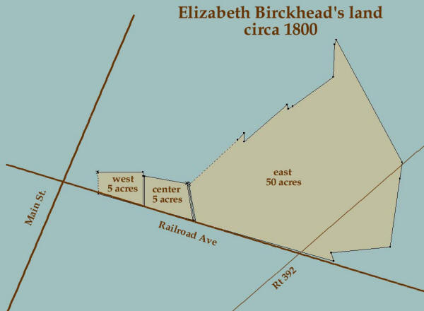
[Elizabeth Birckhead owned three lots. The East Lot comprises 50 acres on the north side of Railroad Avenue near Route 392. The Center Lot contains 5 acres along the north side of Railroad Avenue. The West Lot comprises 5 acres on the north side of Railroad Avenue. The house known as Buckland is on the West 5 acres.]
[Center Lot] 23 HD 416 - 11 July 1806 - Robert Sulivane to Elizabeth Birckhead for $100: lot conveyed 24 October 1804 to said Robert Sulivane by Ezekiel Richardson as High Sheriff of Dorchester County. Lying near or adjacent to the village of New Market and beginning at a marked white oak being the bounder of a tract of land conveyed by Charles Daffin to Daniel Sulivane and runs southwardly binding with that tract to the main road, then running with the said road to the westward to the corner of the lot belonging to and in the possession of the aforementioned Elizabeth Birckhead, then binding with the line of her lot running northwardly to the corner thereof, then with a straight line to the beginning.
[West Lot] 23 HD 194 - 27 November 1805 - James Sulivane Senior to Elizabeth Birckhead for consideration of the sale and conveyance of a parcel of land called "Preston Vale" by James B. Sulivane, Robert Sulivane, Elizabeth Birckhead, and Clement Sulivane to Daniel Sulivane, son of the said James Sulivane Senior and $1: lot in the village of New Market which is part of a tract called "New Market". Beginning at a bounded cedar post marked with 7 notches standing to the northeastward of the said James Sulivane's store house, that was about 10 or 12 perches distant there from, thence running E 36 perches, then S 27 1/2 perches to the middle of the main road, then with the middle of the said road and bounded therewith N 74 W 37 3/4 perches, until it intersects a line drawn S from the beginning and then with that line reversed to the beginning. Containing 5 acres.
[Center Lot] 20 HD 557 - 24 October 1804 - Ezekiel Richardson, Sheriff of Dorchester County, to Robert Sulivane for 35 pounds, 12 shillings, 6 pence: On 10 February 1802, a writ in the name of Clement Sulivane against James Sulivane out of the General Court of the Eastern Shore, the Sheriff of Dorchester County is ordered to sell the lot of James Sulivane. Beginning at a marked white oak bounding a tract bought by Daniel Sulivane of Charles Daffin and runs southerly binding with that tract to the main road, then running with the said road to the westward to the corner of Elizabeth Birckhead's lot, then binding with the line of said lot northerly to the corner thereof, then with a straight line to the beginning. Containing 5 acres.
[East Lot] 17 HD 276 - 1 December 1800 - Commission of Henry Hicks of Denwood, Jacob Wright, Thomas Jackson, Ezekiel Richardson, and Henry
Smoot. Whereas James Bennett Sulivane by his humble petition hath
set forth that his father Doctor Daniel Sulivane died intestate, seized
of considerable landed estate and leaving the following children to wit,
you petitioner, Robert Sulivane, Elizabeth Birckhead, and Clement
Sulivane, the last of whom is a minor, his heirs at law. James
Bennett Sulivane is the lawful guardian to the said Clement Sulivane who
is a minor under the age of 21. The commissioners divide 933 1/2
acres into four equal allotments.
(4) 50 acres with large and well improved lot in New Market, To
Elizabeth Birckhead. Beginning of the 4th lot, which has the
additional value of a well improved lot within the town of New Market at
a marked white oak standing on the south side of the old county road as
it formerly ran from New Market to Crotcher's Ferry noted by the letter
F on the plat, then to run S 9.75E 30p, then S74E 114p, with the
direction of the road which leads from New Market to Vienna where stands
a post set down in the direction of the 1st course of the tract called
"Ridgy Land", from thence N17W 7p to a post which stands on the north
side of the road which makes into the former road then with the
directions of that road N81E 47p, N88E 55p, then N77E 13p to a post set
in the line of the N20W 111p course of the aforesaid "Preston Vale",
then with that line to the end thereof N20W 48p, S82W 26p, S54W 40p,
S60W 46p to a post set down in the direction of the 1st course of the
aforesaid "Ridge Land", thence N17W 35p to the intersection of the land
called "Melvills Meadows", thence bounded by that line the following
courses S49W 45p, N 87p to a marked post set down in the direction of
the home course of the aforesaid "Ridge Land" then reverse with that
line S44W 75p to a post, then by a line to the 1st place of beginning.
Containing 50 acres. Being the late dwelling of Daniel Sulivane,
deceased.
Herald and Eastern Shore
Intelligencer - 18 November 1800 - For Sale -
Robert Sulivane, Clement Sulivane, New Market, executors to hold sale on
the farm where Capt Christopher Birckhead formerly lived, estate of
James Birckhead, deceased.
Herald and Eastern Shore
Intelligencer - 15 October 1800 - Died -
Sunday week last, James Birckhead, merchant of New Market.
Herald and Eastern Shore
Intelligencer - 19 November 1799 - For Rent -
Dwelling plantation for rent in lower part of Talbot Co, owned by
Christopher Birckhead, deceased, apply to James Birckhead, New Market.
Marriage Record - 2 February 1797 - James Birckhead to Elizabeth Sulivane
1783 Tax Record
James Sulivane
New Market 897 3/4 acres.
1 framed
dwelling house, 4 small houses, 1 carriage house, 1 brick house, 4
logged houses, and 2 orchards. The land was situated in New Market.
The soil was clay with 450 arable acres, and 447 3/4 wooded acres.
The value was 1200£.
[These three lots are part of the 933 acre "New Market" tract resurveyed by James Sulivane in 1776. The tract on which the house known as Buckland now stands can still be recognized as being on the south 50 acres original "Westward" tract prior to 1776.]
50 BC & GS 471 - 30 October 1776 - Resurvey of Buckland Regulated, Debate Enlarged, Restitution, Sulivane's Meadows, Westward, York, and several pieces of vacant land to create the tract New Market.
19 Old 7 - 23 June 1763 - Bartholomew Adams, Joyner, and Elizabeth, his wife of Dorchester County to James Sullivane of the same county: 50 acres called "Westward" formerly sold by John Anderton to John Rix, grandfather of Elizabeth Melvil, now Elizabeth Adams, wife of said Bartholomew Adams; said Bartholomew and Elizabeth, on June 15th last, having conveyed to said James Sullivane, part of "Bucklands Regulation" which was said to contain 216 acres more or less, but which only contains 166 acres adjoining "Westward"
Liber 27, Folio 209 - Will of John Rix - 13 July 1748 / 7 January
1749 -
Item 1 - I give and bequeath unto my daughter Bettey Rix my now dwelling
plantation with all the land belonging to it to her and her heirs of her
body lawfully begotten or her assigns forever and for want of such heirs
then my will and desire is that the Plantation before mentioned with the
land belonging thereto fall and go to my Grand Daughter Elizabeth
Melvill to her and her heirs and assigns forever. I likewise give
unto my daughter Bettey Rix fifty acres of land that I had of John Anderton
to her and her heirs and assigns forever and for want of such heirs then
my will and desire is that the Plantation before mentioned with the land
belonging thereto fall and go to my Grand Daughter Elizabeth Melvill to
her and her heirs and assigns forever.
Secondly - I give and bequeath unto my said Daughter Berrey on negro
woman called Daffony and her two children to wit Janly & Tyo to her and
her heirs forever. I likewise give unto my said daughter Bettey
two of my best beds and furniture.
Thirdly - I give unto William Adams, son of Sarah Adams, one cow
yearling
Fourthly - I give unto my daughter Sarah Melvill, twenty shilling sterling
in full part of her portion.
Fifthly - I give unto Isaac Adams all my wearing apparell at my decease
Sixthly - I leave my old plantation adjoining to Daniel Sulivane's to be sold by my
executors
Lastly - I leave my well beloved
Wife Anne Rix and my well beloved friend Daniel Sulivane my whole and
sole executors of this my last Will and Testament
Witnesses John Anderton, Edward Trippe Jr., John Dickinson
11 Old 111 - 29 June 1743 - John Anderton to John Rix in
consideration of 50 acres lying on the east side of the South line of a
tract of land called "Bath" being part of two tracts of land the one
called "Buckland", the other "Debate Enlarged", which by deed bearing
equal date with these presents more fully may appear: part of a tract of
land called "Westward" lying in the fork of Secretary's Creek. Beginning
at the end of three? perches in an East line drawn from a marked post
standing in the middle? of the South line of the said land called
"Westward and being the division between Daniel Sulivane and said
Anderton, then runs E 67p to the north? line of "Westward" and then with
said line drawn N133 1/2p to the end of said line, then W 67p, then
south to the beginning. Containing 50 acres. Together with all houses,
orchards, gardens, lands, and other improvements and appurtenances
thereunto belonging.
[In the early 1800s wording such as "Together with all houses orchards,
etc." became common wording in every deed to indicate whatever was on
that land conveyed with the deed. However, in 1743 this does not
appear to be in regular practice. After analyzing a small
sample of deeds in this volume during 1743, it appears the word houses
was not put in every deed. Out of 9 deeds analyzed almost
all had orchards & gardens. I found 1 with no mention of a
structure 1 with appurtenances, 1 with improvements, 1 with buildings,
and 6 with houses. This needs further analysis with a larger
sample, but with such great variation in the wording, I suspect "houses"
being mentioned in this deed means a house was on this property when
John Anderton sold the land to John Rix in 1743. The property
described is the lower portion of the Westward tract as shown on the
plat. This is where the house known as Buckland now stands.]
Liber 13, Folio 697 - Will of Francis Anderton - 7 December 1713 / 10
March 1714
Item - I give & bequeath to Mary my dearly beloved Wife two hundred and
ninety five acres of land, part of a tract called Bath and fifty acres
part of a tract of land called Westward including my now Dwelling
plantation for and during her natural life.
Item - After my said Wife's decease I give an bequeath the aforesaid
devised lands and plantation unto my eldest son, John Anderton and his
heirs forever.
Item - I give and bequeath unto my son, Francis Anderton a tract of land
containing two hundred acres called York and fifty acres of ye aforesaid
tract of land called Westward next joyning unto the aforesaid tract of
land called York to my said son Francis and his heirs forever.
Item - Whereas in consideration of seaven thousand pounds of good
merchantable Tobacco by me to be payd to William Carr of Talbot County
he had bargained & sold unto me one hundred acres of land called Walkers
Chance lying near the mouth of Hunting Creek, but said tract of land is
norther paid for mad over unto me: now my Will & Desire is that my
Executrise hereafter named procure the said tract of land to be made
over to fee my son James & his heirs forever & pay the aforesaid
purchase to the aforesaid William Carr. But in case it
should so happen that the said William Carr should not make over the
aforesaid tract of one hundred acres of land to my said son James
Anderson that my said executer hereafter named pay to my said son James
out of my moveable estate the aforesaid sum of seaven thousand pounds of
Tobacco.
Item - I give and bequearth to Mary my well beloved Wife, all my
moveable & personal estate for her own suppor & the bringing up and
maintenence of my two daughters Mary and Sarah
Test: Abigail Ricks, John Ricks, John Kicke, Edmund Mackel
[It appears the Will indicates the dwelling plantation was on the fifty
acre part of Westward. The 50 acre Westward tract is where the house
know as Buckland is located. It is possible the Buckland house or
an earlier version of it was at this location in 1713.]
[The tract in the Will above and 11 Old 111 is the lower 50 acres of the 100 acre tract in 6 Old 55.]
6 Old 55 - 8 Nov 1704 - Phillip Taylor of Dorchester County to
Francis Anderton: "Westward", adjoining the land of Wm. Smithson
called "York" on the Nanticoke Indian path from Choptank Indian Fort and
containing 100 acres. Also a 299 acre part of "Bath".
[In his 1705 Will, Phillip Taylor referred to Francis Anderton as his
godson.]
5 Old 120 - 2 August 1698 - Edward Taylor to Phillip Taylor for 4000 pounds of tobacco: tract on the south side of the Great Choptank River in the forrest Daffou by the name of "Westward". Beginning at a marked Hickory standing by the side of a Nanticoke Indian path from the Choptank Indian Fort, being the first bounder tree of the land of William Smithson called "York", from thence running bounded with the said land East 60? perches to a marked oak being another bounded tree of the said land, from thence running North 267 perches to a ... ... running West S 60? perches, and so from thence running South 267 perches to the first specified marked hickory. Containing 100 acres.
[The deeds below provide clues as to when a dwelling house first stood at this location. The various tracts which are the primary focus of each deed below are not the tract on which the house known as Buckland stands. Most are adjoining or nearby the tract.]
14 HD 42 - 5 March 1798 - John Tootell, late High Sheriff of
Dorchester County to Edwards Thompson for 100 pounds: whereas in
1794 the General Court of the Eastern Shore directed the sheriff to sell
good, chattels, lands, and tenements of James Sulivane, late of
Dorchester County to pay debts of 2000 pounds due to William Barclay.
Sheriff directed to seize (1) one lot in New Market being a part of a
tract called "New Market" about 1 1/2 acres of land with a store house
and granary and sundry other parcels of land and other things amounting
as by the appraisement to 1390 pounds to satisfy the said William
Barclay. The lot with the store house and granary was sold at
auction to Edwards Thompson. Beginning at a marked cedar post laid
at the end of the 3rd course of the lot whereon Doctor Daniel Sulivane
now lives, and thence running and binding with the home line of the
aforesaid Doctor Sulivane's lot N 2 W 15 1/2 perches to another marked
cedar post, thence S 89 W 12 3/4 perches to another marked cedar post,
thence S 2 E 12 perches to the main road leading from New Market to
Vienna and binding and running with said road to the first beginning.
Containing 1 acre. Also all right & title to the said Store House,
Granary, and lot of land specified. In 1797 the sheriff sold
another part of James Sulivane's lands to pay his debt to William
Barclay, one lot in New Market with a cabinet makers shop for 25 pounds.
[the lot whereon Daniel Sulivane now lives is the house known as
Buckland adjoining to the west.]
14 HD 283 - 29 June 1798 - James Sulivane to Edwards Thompson for 50
pounds: a lot in the village of New Market being part of a tract
called "New Market". Beginning at marked cedar post fixed at the
end of the 3rd course of a lot whereon Doctor Daniel Sulivane now lives,
and thence running and binding with the home line of the aforesaid
Doctor Daniel Sulivane's lot N 2 W 15 1/2 perches to another marked
cedar post, thence S 89 W 12 3/4 perches to another marked cedar post,
thence S 2 E 12 perches to the main road leading from New Market to
Vienna and binding and running with said road to the first beginning.
Containing 1 acre.
[the lot whereon Daniel Sulivane now lives is the house known as
Buckland]
9 NH 105 - 19 September 1786 - John Hutchinson and John Brinsfield to
Charles Daffin, merchant for 66 pounds, 1 shilling, and 3 pence: Part of
a tract called "Ridgy Land" near New Market. Beginning at a marked
white oak standing in the edge of Cow Savannah and near a path from John
Rixes to David Melvons (Melvills) dwelling house, then runs S17E 145p,
then S10W 13p, then W 20p, then N50W 120p, then with a straight line to
the first beginning. Containing 50 acres. Elizabeth
Hutchinson, wife of John Hutchinson.
[Assumed the path is from John Rixes dwelling house even though a John
Rix dwelling house is not specifically mentioned. This path is
near the northernmost point of the tract called Ridgey Land and runs
from there southwest along the northwest line of the tract. See
the
plat.]
2 NH 543 - 23 July 1784 - James Sulivane & Mary Sulivane his wife, to
Theophilus Marshall for 64 pounds: 13 1/4 acre tract called "New
Market". Beginning at a marked cedar post standing in a lane
between the said Sulivane and Marshall and near where the original
dwelling house of a certain Isaac Adams, deceased, formerly stood, and
then runs N 35 W83 perches, then N 39 E 54 perches, then with a straight
line to the beginning. Containing 13 1/4 acres.
[This tract is southwest of town at the westernmost edge of the New
Market tract in the part labeled Carthagena within the dotted lines
shown on the
plat. This is not the house known as Buckland.]
2 NH 403 - 8 December, 1782 - Whereas John Anderton by his humble
petition prays a Commission to perpetuate the boundaries of his lands
called "Debate Enlarged" and part of "Westward". Commission
appointed. James Sulivane enters himself as defendant.
(1) Deposition of Roase Standley aged about 50-60 - she lived with John
Ricks, that he showed her, this deponent, a bounded white oak and a red
oak grew from the root of said oak and that her master John Ricks said
it was his bounder. She cannot remember what bounder it was, only
he said it was his bounder and that none of them was to stick and ax in
his bounded tree. Some years ago (upwards of 30), Mr. Daniel
Sulivane, deceased, was over the Bay, but before he went he had
purchased a mulatto man by the name of James Whutchick, and while Mr.
Daniel Sulivane was over the Bay, he Whutchicks barked the said trees
for tan bark. She saith that no tree grew near the said trees.
She further saith that the place now shewn is as she thinks near the
place where the bounder stood as may be, but she cannot swear to any
particular spot where the bounder stood, but she believe that it stood
within ten yards of the spot now shewn and she saith further that she is
clear in it she cannot say how far around the bounder the land was
cleared. She further saith that John Ricks shew her the bounder
upwards of 20 times. She saith the bounder was larger then a
common persons body and that it was a live tree and that there was
chopts in said tree. She has heard Ricks and Whutchicks both say
that Whutchicks barked the said tree.
(2) Deposition of Sarah Melvill, aged upwards of 80 years - saith that
the bounder of her father's land stood about 100 yards or upwards to the
southward of a Hickory Tree,. Was a boundary of Francis Anderton's
land. Bounder of her said father's land stood near the edge of a
swamp. John Ricks was her father. The name of the land was
"Debate Enlarged". She cannot say what kind of wood the bounder
was. She does not remember whether it was the 1st, 2nd, or 3rd
bounder of "Debate Enlarged". She did not see the land run, but
she knew who run it, and when Saunders? Hodson, or Hays run it, she does
not remember the way they came. She saith that Francis Anderton
informed her that the Hickory was the bounder of his land. She
believes the name of Anderton's Land to be "York".
(3) Deposition of Nathan Bradley, aged upwards of 37 years - saith about
6 years ago he carried the chain for Mr. Sulivane under Mr. William
Davis, surveyor. Near the place where Roase Standley showed, that
Mr. James Sulivane came down to this place or near it and made beginning
and run towards the Hickories.
(4) Deposition of John Hutchinson, aged about 26 years - , saith about 6
years ago, he carried the chain for Mr. James Sulivane under Mr. William
Davis, surveyor. with Nathan Bradley. He says he cannot
remember where the bounder was nor how it was. He believes he run
a north course where the beginning was. He believes the beginning
was near this place. He remembers running near the house where
William Troth now lives.
(5) Deposition of Mary Adams, aged about 73 years - Saith she remember a
bounder tree near this place which was John Rix's bounder. She was
informed by Isaac Adams, her husband, deceased. She saith this was
her husband's and father's land and her lived with him and bred him up.
She believes the bounder to be in this bottom or near this place or the
place where Roase Standley new shews. She saith it was in the edge
of woods and does not think the land to be cleared at the time.
(6) Deposition of William Davis, aged about 42 years - He was called by
Mr. James Sulivane about 7-8 years ago to make a resurvey for said
Sulivane on several tracts and parts of tracts. The aforesaid
Sulivane shewed him a place to begin the aforesaid tract called "Debate
Enlarged". He thinks it may be about N 34 W 19-20 yards from the
place shewn by Roase Standley.
(7) Deposition of Luke Stevens, aged about 53 years - saith that about
20 years ado, Major Daniel Sulivane, father of the present James
Sulivane showed him a bounded white oak standing, but then dead, and
said it was a bounded tree of "Debate Enlarged". The place now
shewn is as near the place where the tree stood as he can come.
Said Stevens shoed another place where he says the Smith Shop
stood, formerly belonging to Major Daniel Sulivane. Major Daniel
Sulivane when he showed him the said boundary of "Debate Enlarged" was
running lines of a tract called "York" from the 2nd boundary. He
was one of the chain carriers. He was told by Major Sulivane that
the bounder was killed by Whitcharp pealing the bark for tan bark.
Major Daniel Sulivane showed him a white oak and told him it was the 2nd
boundary of "York". He saith that the said boundary of "Debate
Enlarged", shown by Major Daniel Sulivane stood near the woods or swamp.
He further saith he knows the place now shown for the first boundary of
"Debate Enlarged" from passing frequently for many years by the boundary
to the shop to get his work done. Viewing from the shop and
conversing about it and by tobacco ground that afterwards was around the
swamp and from a barn that stood not far of that, he does not remember
any person in particular, but Major Sulivane that he conversed with
about the boundary. He saith that he conversed with above 20
people about the 2nd boundary of "York", but cannot remember any person
in particular, but Major Sulivane. He cannot tell who carried the
chain with him, but thinks it was Whitchiks or Elbert. Major
Sulivane told him the first boundary of "York" stood here.
(8) Deposition of Mary Adams, aged about 75 years - saith that since her
former deposition, she recollects a certain Hugh Williams showed her a
bounded tree, which stood at the place where Rose Standley and Luke
Stevens showed the tree to stand and told her it was John Rix bounder
tree. She has seen the tree 100 times since. She thinks it
is near 30 years ago since Hugh Williams showed her the said tree.
The said Williams was brought up by John Rix and lived in the
neighborhood.
(9) Deposition of Thomas Badley, aged about 30 years - saith that about
20 odd years ago when he imagines he was 8 or 10 years old, that one,
Frederick Berry, a blacksmith, who worked for Mr. Daniel Sulivane, one
day when he was at the shop told another man named Mark Cook, who is
since dead, pointing to a tree with a broken top, said it was a bounder.
The deponent does not recollect that the said Frederick mentioned what
bounder it was, or what land, or to whom the land belonged. He has
seen the said tree several times since as he passed by to Mill. It
stood near the swamp. The place shown by the deponent bears N 19 W
12 strides from the place shown by Rose Standley.
Commissioners state that they have caused a cedar post marked with 12
notches, 3 on each side, to be set down in the same place so by them
proved. The said cedar post stands at the end of a line drawn S 15
W 22 1/4 perches from 2 large Hickory trees which stand in the cleared
ground about N 42 E 20 1/4 perches to the place where the late dwelling
house of old Mr. Daniel Sulivane, deceased, which was burnt down
formerly stood and which same Hickory trees stand close together and are
the same Hickory trees mention in the depositions.
[The deed above further establishes that Rix lived on his land in this
area. It also provides information that Mr. Daniel Sulivane's
house burned down. The bounder referred to is on the east side of
the Debate Enlarged tract and the west side of the Westward tract.
The bounder is most likely at the north east corner, which would put the
burned down house near the south side of Railroad Avenue, maybe around
where the J.R. Phillips house is on the 1877 map. This would be
just north of the northern boundary of Debate Enlarged. The
bounder may also be the south east corner of Debate Enlarged, placing
the house just north west of the A on the
plat which is close to the present day Friendship Hall.]
25 Old 25 - 8 April 1771 - To make estimate of the annual value of a
certain plantation belonging to John Adams, son to Isaac Adams,
deceased, being part of a tract called "Carthagena" containing 100 acres
under the guardianship of a certain John Anderton. Estimate 2/3 of
the land and plantation to be the annual value of 4 pounds, 10 shillings
to be paid by John Anderton to John Adams when he reaches age 21.
Land has 1 dwelling house 28 feet long, by 15 feet wide; an
addition to the house 15 feet long by 14 feet wide in bad repair;
an old Kitching 15 feet long by 13 feet wide not worth repairing;
one milk house 6 feet long by 8 feet wide in bad repair; 1 logged
house 10 feet long by 8 feet wide not worth repairing; one logged
house 17 feet long by 15 feet wide with a logged shed 15 feet long by 8
feet wide in good repair; one apple orchard with 25 apple trees,
on nursery mixed with apple, peach, and cherry Siannas containing in the
whole 47, 81 small apple trees lately planted out and about 892 panels
of fencing in middling repair. We do hereby order the said John
Anderton, guardian to the said John Adams, to make the following
repairs: the dwelling house to be mended around the chimney with
shingles so as to make it tight; the addition on the south side
covered with 18 inch shingles to be rounded as also to be new silled;
the milk house to be weather boarded on the west side and to be mended
all round with clapboard. The said guardian to have liberty to
clear 2 acres on the north side of the said plantation towards Mr. James
Sulivane's to keep the plantation in repair and also firewood for the
use of the houses. The repairs are valued at 5 pounds to be
deducted from the annual value of the land.
[This house is south of town in the part of the New Market tract known
formerly known as Restitution on the
plat. This is not the house known as Buckland.]
Will of John Anderton - 22 July 1760 / 10 April 1767
Land to be divided between sons, John and Francis Anderton
To daughter, Sarah Anderton - one slave
Children: John, Francis, Sarah, and Betty.
I have already given daughter Betty King, part of personal estate.
Desire that what she had already received shall be part of her portion.
Executor: son, John
Witnesses: Daniel Sulivane Jr., and Sarah Sulivane, Catherine
Cannon.
Codicil: 8 January 1761 - son-in-law Robert Clarkson - one slave
Witnesses: Daniel Sulivane, Henry Trippe.
15 Old 510 - 9 March 1757 - Nehemiah Boxall, planter, to John
Hutchinson, planter, for 8 pounds money and 1200 pounds of tobacco:
Land called "Ridgey Land". Beginning at a marked white oak
standing by the edge of cow Savannah and near to a path that leads from
John Rixes to David Melvill's dwelling house then runs S17E 145p, then
S10W 13p, then W 20p, then N50W 120p, then with a straight line to the
first beginning. Containing 50 acres more or less.
[Assumed the path is from John Rixes dwelling house even though a John
Rix dwelling house is not specifically mentioned. This path is
near the northernmost point of the tract called Ridgey Land and runs
from there southwest along the northwest line of the tract. See
the plat.]
14 BC & GS 259 - 7 August 1750 - By virtue of a special warrant
granted unto Daniel Sulivane bearing date 16 February 1750 to resurvey a
tract called "York", Originally on 10 August 1683 granted unto a
William Smithson for 200 acres under new rents.. I humbly certify
that the ancient meets and bounds of the aforesaid tract of land are as
follows: Lying on the East side of the Chesapeake Bay on the south
side of the Great Choptank River in the woods of Dorchester County.
Beginning at a marked hickory standing on the side of the Nanticoke
Indian Path from the Choptank Indian fort, from thence running East 60
perches to a marked oak, from thence running South 1/2 point Easterly
357 perches, from thence running West 120 perches, from thence running N
1/2 point East 357 perches to the first specified Marked Hickory.
Containing 200 acres. I humbly certify that I have resurveyed for
and in the name of Daniel Sulivane, the aforesaid tract which is said to
contain 218 1/2 acres to which added 50 acres of vacant land and have
reduced the whole into one entire tract still called York.
Beginning for the bounds of the whole tract at a marked post standing in
the place where the first original bounder of the aforesaid land called
"York" stood and about 100 yards southwest of the said Sulivane now
dwelling house than runs S89E 70 perches to a marked white oak then S
1/2 a point E 160 perches then E 13 perches, then S 1/2 a point E 218
perches then W 75 perches, then N 20 perches, then W 68 perches, N3/30E
289 perches, then N45W 48 perches, then S7W 20 perches, then W 13
perches, then N 138 perches, then E 25 perches then S 116 perches, then
by a straight line to the first beginning. Containing 268 acres.
[The marked hickory is to the west of Friendship Hall.]
Liber 26, Folio 20 - Will of David Melvill - 14 January 1748 / 11
April 1749
To son David Melvill - my now dwelling plantation called "Thames Street"
and in default of heirs my daughter Sarah Melvill
To daughter Mary Melvill - 1 plantation called "Thames Street's
Addition", and in default of heirs my daughter Betty Melvill
To wife Sarah Melvill - 6 pounds exclusive of her 1/3 part of estate.
Wife Sarah executor
Witnesses: Dan Sulivane, John Rix, Humphrey Hubbard
14 Old 331 - 25 Jan 1748 - John Rix and Ann, his wife, to Daniel
Sullivan 56 pounds: part of a tract called "Debate Enlarged", by
resurvey called "Buckland Regulation", adjoining to the said Daniel
Sullivan's now dwelling plantation whereon formerly John Rix did dwell.
Beginning at a bounded hickory being the first bounder of a tract called
"York", then runs 14p to a bounded white oak being the first bounder of
the aforesaid "Debate Enlarged", then running S87W 30p to a tract called
"Bath", then with the line of "Bath" till it intersects an East line of
the said land sold by the said John Rix to John Anderton, then with the
said East line until it intersects the line of a tract called
"Westward", then running with the line to the first beginning.
Supposed to contain 25 acres.
[This deed shows that the house where Daniel Sulivane now lives and
where John Rix formerly lived adjoins "Buckland's Regulation" / "Debate
Enlarged" tract, thus the house is not on this tract. The tract to
the immediate north was then owned by Anderton, so it is very likely
that the house referred to is on the Westward tract, which very well
could be the house known as Buckland.]
13 Old 12 - 13 June 1745 - John Rix to Daniel Sulivane for 16 pounds:
part of a tract called "Buckland Regulated" being the lower part of the
said land adjoining the said Sulivane's dwelling plantation. Beginning
at a slipd oak being the division tree of a tract of land called
"Westward", then runs S51E 51p, then SW 24p, then S50E 90p, then S54W
112p, then N 171p to the aforesaid slipd oak. Containing 47 acres.
[This deed is a jagged triangular tract to the adjoining the east side
of the Westward tract. This further confirms that a house was on
the Westward tract, and likely was the house known as Buckland.]
1 BY&GS 102 - 4 December 1743 - By virtue of a warrant granted Thomas
Gough of the city of Annapolis for 500 acres of land bearing date 28 Jun
1743, and the same day assigned to Major Henry Trippe of Dorchester
county whereof 10 acres is by Trippe assigned to Daniel Sulivane a tract
of land called "Addition to York". Beginning at a marked white oak
standing in or near the south half of the east course of land called
"York" and about 40 p distance from second bounder of said land on the
east side of Dr. Sulivane dwelling plantation, then running south 1/2 a
point east 120 p, then N37E 23p, then N and by W 46p, then E 27p, then N
75p to the first beginning.
[This land would be near the southeast part of the large York tract on
the
plat. The dwelling plantation being referred to is likely
Friendship Hall or an area south of Friendship Hall.]
12 Old 99 - 13 March 1738 - Commission to Jacob Hindman, Isaac
Nicholls, Solomon Edmondson, and Philemon LeCompte, Gentlemen, to
perpetuate the bounds of Daniel Sulivane's land called "York".
Deposition of Mr. Peter Taylor Senr, aged 59 years or thereabouts, taken
13 July 1739 - about 42 years ago, Thomas Pattison surveyed "York" and
told this deponent that the first bounded tree of "York" was a bounded
hickory standing by an Indian path which went by a hickory which now
stands in the said lane between Daniel Sulivane and John Rix and from
the said hickory about five yards to the northwestward stood the first
bounded hickory of the land called York and the father of this deponent,
Major Thomas Taylor, late of Dorchester County, showed this deponent
this aforesaid bounded hickory which now stands in the lane that now is
between Daniel Sulivane and John Rix.
Deposition of David Melvill Senr, aged 58 or thereabouts, taken 13 July
1738 - About 36 years ago Thomas Trisler? late of Dorchester County,
showed this deponent, this marked hickory which now stands in the lane
which is now between Daniel Sulivant and John Rix about 100 yards from
the aforesaid Daniel Sulivant dwelling house. It is the first
bounded hickory of the land called York. Hickory is to the
westward of the land called York and Westward.
Boundary is five yards to the southeast from the place where the first
tree stood, by the said David did not understand by his informer that
the first tree was down. The Hickory now standing is in a layne
which parts the plantation of the aforesaid Daniel Sulivant and John Rix
and to the west southwestwards of the aforesaid Daniel Sulivant dwelling
house.
[The lane referred to may be between the left arm of York (Sulivane) and
the west side of Debate Enlarged (Rix) on the
plat. About 100 yards east of this lane places the house in
the middle of the Debate Enlarged tract. The home could also be
100 yards northeast, southeast, south, etc. Likely the house is
100 yards northeast of the bounder and is the house that burned down
before 1782.]
16 / 387 - 15 March 1731 - Inventory of Francis Anderton -
Appraisers: Daniel Sulivane, John Ricks Creditors: Thomas Nevett,
Peter Taylor.
Next of kin: John Anderton, Peter Taylor Executors:
John Brown, Sarah Anderton
Liber 20, Folio 168 - Will of Francis Anderton - 24 March 1730 / 8
April 1731
To sister Sarah and heirs, 200 acres "York" and 50 acres of "Westward"
sister Sarah and brother in law, John Brown executors, residue of estate
equally.
Test: John Briggs, Thomas Smith, Henry Murray
[This is the northern 50 acres of "Westward" and not the site of the
house called Buckland.]