East New Market
Property Reports
106 Main Street
Willoughby Funeral Home
(Also known as Zeller Funeral Home, and H.H. Willoughby & Son, Funeral Director)
Key date analysis:
In 1905, Howard H. Willoughby began leasing a lot at this location from Emma Helsby Smith & her husband James M. Smith. Earlier in 1905, he had purchased a carpenter's shop from Thomas D. Hooper that stood on the back of this lot. Hooper had likely been leasing the lot from Mr. & Mrs. Smith. This became the site of the building that housed H.H. Willoughby & Son Funeral Directors. Willoughby also made and sold furniture from this location. In 1916, Willoughby purchased the property outright from Emma & James Smith. The lot was a convenient location for his business as Willoughby lived on the adjoining lot that he purchased in 1890. The house is known as the Howard Willoughby House.
Who built it:
Howard H. Willoughby likely built the Funeral Home around 1906.
Longest Residents:
The Willoughby family owned the funeral home for over 70 years.
More Research:
Historic Records:
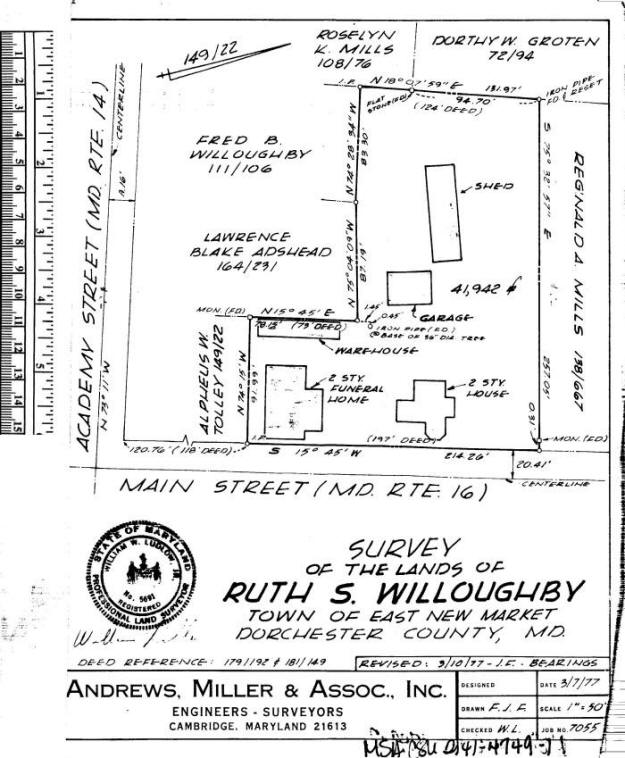
231 MLB 621 - 31 July 1984 - Leonard D. Zeller and Leonard W. Zeller to Leonard D. Zeller & Christine M. Zeller, his wife, for $0: Lots - one lot on the west side of Main Street in the town of East New Market described in accordance with a plat entitled "Survey of the Lands of Ruth S. Willoughby, Town of East New Market", dated March 7, 1977, prepared by Andrews, Miller, & Assoc., Inc. Engineers-Surveyors, in 19 PLC 41. Beginning on the west side of Main Street at the extreme northeast corner of the land herein intended to be conveyed and at the extreme southeast corner of the land of Reginald A. Mills (138 PLC 667), thence leaving Main Street and running with the line of division between the land herein intended to be conveyed and the land of Reginald A. Mills, N75/32W .31f to a monument, thence N75/32W 257.05f to an iron pipe and to the land of Dorothy W. Groten (Liber 72, folio 94), thence S18/07W 37.27f to an iron pipe, thence with the land of Fred B. Willoughby (Liber 111, folio 106), S74/28E 83.3f, thence with the land of Lawrence Blake Adshead (Liber 164, folio 231), S75/04E 87.19f, thence S15/45W 78.15f to a concrete monument, thence S74/15E 91.99f to the west side of Main Street, thence running with the west side of Main Street N15/45E 214.26f to the place of beginning. The land is the identical property which was conveyed unto the said Leonard D. Zeller and Leonard W. Zeller, by deed dated 16 March 1977 in 199 PLC 169.
199 PLC 169 -16 March 1977 - Ruth S. Willoughby to Leonard D. Zeller and Leonard W. Zeller for $5: [described in 231 PLC 621]. The land is the identical land which was conveyed unto the said Ruth S. Willoughby by two deeds; viz: (A) Deed dated 27 August 1973 from William O. Corkran et al, personal representative to Ruth S. Willoughby in 181 PLC 149. and (B) Deed dated 30 March 1973, from Howard H. Willoughby to Ruth S. Willoughby in 179 PLC 192.
181 PLC 149 - 27 August 1973 - William O. Corkran and Robert W.
Corkran, personal representatives of the estate of Fred B. Willoughby,
to Ruth S. Willoughby for $5: Whereas Fred B. Willoughby departed
this life, testate on 6 January 1973 possessed of the land hereinafter
described. Whereas the said Fred Willoughby by a first codicil to
his last Will and Testament, dated 22 June 1959, did give, devise and
bequeath unto his daughter-in-law, Ruth S. Willoughby, the first and
prior right to purchase at appraised value filed in the Orphans Court
for Dorchester County, all of the real estate, including the funeral
parlor and adjacent dwelling house, land and outbuildings, in the town
of East New Market, together with all the personal property incident to
the operation of said funeral and undertaking business. Whereas
the said Ruth S. Willoughby has notified said William O. Corkran and
Robert W. Corkran, personal representatives of Fred B. Willoughby's
estate, in writing, of her intention to exercise the said option, as
required by said Will. All those three lots within the corporate
limits of the town of East New Market as described.
Lot No. 1: Lot which passed to the said Fred B.
Willoughby by operation of law upon the death of his father, Howard H.
Willoughby. Land which was conveyed unto the said Howard H.
Willoughby by Joseph F. Harris & Sallie J. Harris, his wife, by deed
dated 12 August 1890 in 14 CL 295. Lot lying on the western side
of the county road leading from said town to Cabin Creek at the point of
intersection of division line between the lot now sold and the lot of
ground owned by Mrs. Helen Helsby, then with said division line in a
westerly direction 257f, to the land of Samuel L. Webster, then in a
northerly direction 64f to the lot of ground sold by the said Andrew F.
Dukes & Mary E. Dukes, his wife, to William J. Varnes, then with said
lot 257f to the county road, and from thence with said road 64f to the
place of beginning.
[Lot No. 1 is the site of the
Howard Willoughby House]
Lot No. 2: Lot which passed to the said Fred B.
Willoughby by operation of law upon the death of his father, Howard H.
Willoughby. Land which was conveyed unto the said Howard H.
Willoughby by Thomas D. Hooper & Lulu Hooper, his wife, by deed dated 12
October 1905 in 31 CL 308. All the carpenters shop now occupied by
the said Willoughby on the west side of the county road running from
said town to Cabin Creek and on the lot belonging to Mrs. Emma H. Smith
between the dwelling house formerly occupied by Cassidy C. Rawlings and
the dwelling of the said H.H. Willoughby.
[Lot No. 2 is the site of the Willoughby Casket
Manufacturing building.]
Lot No. 3: Lot which passed to the
said Fred B. Willoughby by operation of law upon the death of his
father, Howard H. Willoughby. Land which was conveyed unto the
said Howard H. Willoughby by Emma H. Smith & James M. Smith, her
husband, by deed dated 31 July 1916 in 3 WHM 431. Beginning at a
point on the western side of Main Street 20f north from the dwelling
formerly occupied by Cassidy C. Rawlings, and from thence running with
said Main Street in a northern direction 73f, thence west to the
property occupied by Saxton & Parker, thence with same in a southern
direction 73f, and thence in a straight line to the place of beginning.
Daily Banner - August 20, 1925
- East New Market Items
A very severe storm visited this section last Thursday night about
midnight. Much damage was done by the wind and the torrents of rain
which fell. A large plate glass window in Mrs. Mary K. Willey's store
was blown in. Two trees were blown down, one in
Mr. H.H. Willoughby's yard, which fell on his corn house and crushed in
the roof, the other in Mr. T.H. Collins' yard, where no damage
was done. A large branch fell from a tree in front of Mr. John Smith's
and hit a passing automobile, but did not damage the car.
Daily Banner - July 3, 1925 -
East New Market Items
Mr. H.H. Willoughby is improving his undertaker's establishment with a
coat of paint.
3 WHM 431 - 31 July 1916 - Emma H. Smith & James M. Smith, her husband, to Howard H. Willoughby for $5: land in East New Market beginning at a point on the western side of Main Street 20 feet northward from the dwelling formerly occupied by Cassidy C. Rawlings, and from thence running with said Main Street in a northern direction 73 feet, thence west to the property occupied by Saxton & Parker, thence with same in a southerly direction 73 feet, and thence in a straight line to the place of beginning. Being the same property described in a lease from the grantor unto the grantee dated 7 December 1905 in 31 CL 366 and as now occupied by the grantor.
1915-1917 Dorchester County Commercial Directory - East New Market
Howard H. Willoughby, furniture & undertaker
1912-1914 Dorchester County Commercial Directory - East New Market
Howard H. Willoughby, furniture & undertaker
1909-1911 Dorchester County Commercial Directory - East New Market
Howard H. Willoughby, furniture & undertaker
1908-1909 Dorchester County Commercial Directory - East New Market
Howard H. Willoughby, undertaker/furniture
1906-1907 Dorchester County Commercial Directory - East New Market
Howard H. Willoughby, furniture & undertaker
31 CL 366 - 7 December 1905 - Lease for 99 years - Emma H. Smith & James M. Smith, her husband, to Howard H. Willoughby in consideration of the rent or yearly sum of $20: land in the town of East New Market beginning 20 feet from the dwelling formerly occupied by Cassidy C. Rawlings, and now occupied by William S. Clifton, thence running with the main street 73 feet, thence west 80 feet, thence south 73 feet, thence back to the place of beginning. Being the same property inherited by the said Emma H. Smith, then Emma H. Helsby, from her father Freeley H. Helsby.
East New Market Cemetery
Helen Helsby d. 6 January 1897
1896-1910 Tax Record
Helen Helsby
1896 - 1 store house in ENM $1000
Dwelling & lot adjoining store house $600
2 small dwellings & lots near the store house $500
1896 Tax
Record
Helen Helsby
1 store house & lot in East New Market $1000
1 Dwelling house & lot adjoining the store house $600
2 small dwelling house & lots near the store house $500
Democrat & News - 4 January 1890
- Wedding -
Miss Addie Dean, daughter of J.W.M. Dean, Esq., a prominent farmer and
Mr. H. H. Willoughby were married this morning at St. Stephens Church.
1876 Tax
Record
Causine Helsby
1 corner lot & shop in ENM 1/8 acre - $300
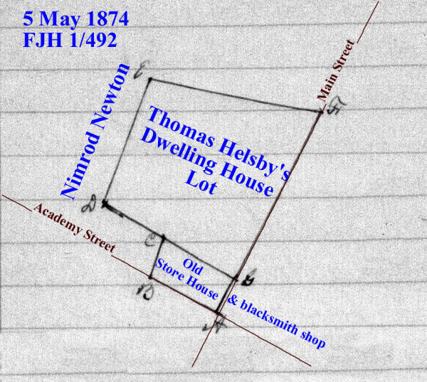
1 FJH 492 - 5 May 1874 - Causine Helsby to divide the lands of Thomas Helsby, deceased: A certain Thomas Helsby departed this life in the year 1865, intestate, and seized of certain real estate in the town of East New Market and leaving Frelinghuysen Helsby and your petitioner, the said Causine Helsby his only children and heirs at law, but the said Frelinghuysen Helsby departed this life, intestate, in the year 1872, leaving Emma Helsby his only child and heir at law, who is an infant under the age of 21 years. The petitioner prays that a commission fairly and equally in value between the parties interested. A commission of Kendall M Jacobs, John WM Dean, John W Fletcher, Thos K Smith, and Thos Leckie was appointed. The real estate situated in the town of East New Market consisting of a dwelling house & lot including an old store house & blacksmith shop on the same, and an arable lot of land detached from the dwelling house and lot and adjoining the school house in said town. Running a line from a stone on the Main Street straight to a stone near the fence of Nimrod Newton giving and allowing to Emma Helsby, infant child of Frelinghuysen Helsby, all of the lot and dwelling house and other buildings on the north of said straight line. To the said Causine Helsby, all that part of the house & lot above described lying on the south side of the line as above described running from the Main Street then intersecting with the said Nimrod Newton's fence including the old store house and blacksmith shop - and also the lots of arable land detached as above described near the Episcopal Church of East New Market, beginning at the east corner of the primary school lot.
1870 Census
Dwelling #
1867-1876 Tax Record
Sarah Jane Helsby
1867 - House & Lot $800
1867 - unimproved lot $150
Nimrod Newton
1867 - House, Lot, & Shop $400
1866 Tax
Record
Sarah Jane Helsby
house & lot $800, unimproved lot $150
Nimrod Newton
House, Lot, & Shop $400
6 FJH 195 - 24 June 1865 - Nimrod Newton to Thomas Helsby for $300: lot in East New Market beginning at the north east corner of an old granary and noted on the plat by letter A, on the side of the county road leading to Cabin Creek and running from thence N73/15W 3p,3f to a lot formerly the property of Nancy McCollister, then with the said lot N18/30E 5p, then N73/15W 30f, then S18/30W to a small ditch, then with said ditch to the bank and fence between said lot and Nimrod Newton's garden, then with said bank and fence to the lot belonging to the heirs of Louisa LeCompte, the with said lot to the county road leading to Cabin Creek, then with said road to the place of beginning. Containing 5/8 of an acre. Said premises has been in the possession of the said Thomas Helsby from the year 1844.
[Corner Store/Trinity Hall] 5 FJH 134 - 15 November 1861 - Mary Bramble to Thomas Helsby for $325: lot in the town of East New Market bounded on the east by the county road leading to Cabin Creek and on the south by the road leading to Secretary Creek. Also adjoining lot known as the McCollister Lot and purchased by the said Mary Bramble at the sale of the real estate of Jeremiah Bramble, deceased, and bounded in part on the east by the first described lot and on the south by the said road leading to Secretary Creek.
1852-1864 Tax Record
Thomas Helsby
House & Lot, Store House $800, unimproved lot 5 acres $125
1862 Lot in New Market from Mary Bramble $200
1864 by abatement on house & lot in New Market $600
Mary Bramble
House & Lot $800, Blacksmith's Shop $200, Lot, Shop $100
.....reduced
1862 by lot sold to Thos Helsby $100
Nimrod Newton
House & Lot $200
1860 improvements on shop $150
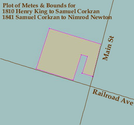
18 ER 237 - 4 February 1841 - Samuel Corkran & Elizabeth, his wife, to Nimrod Newton for $400: Beginning at a stone in the ground at the NE corner of an old granary in the village of East New Market, noted on the plat by a the letter A and running from thence N 73 W 3 perches & 3 feet to a lot formerly the property of Nancy McCollister, then with the said lot N 18 E 5 perches, then N 73 W 30 feet, then S 18 W 7 1/2 perches to the main road leading to the head of Secretary Creek Dickinsons landing, then with the said road N 73 W 11 perches, then N 18 E 12 perches to a post, then S 73 E 15 1/4 perches to the main road leading from New Market to Cabin Creek, then by said road to the beginning. Containing 1 acre.
27 HD 383 - 12 March 1810 - Henry King to Samuel Corkran for $75: Beginning at a stone set on the ground at the north east corner of an old Granary in the village of New Market, noted on the plat by the letter A, and running from thence North 73 degrees West 3 perches, and then set to Nancy McCollisters lot then with said lot north 18 degrees East 5 perches, then North 73 degrees West 30 feet, then South 18 degrees west 7 1/2 perches to the main road leading to the head of Secretary Creek, Dickinson's Landing, then with said road North 73 degrees West 11 perches, then North 18 degrees East 12 perches to a post, then South 73 degrees East 15 1/4 perches, to the main road leading from New Market to Cabin Creek then by said road to the beginning. Containing 1 acre.
20 HD 398 - 25 October 1802 - Commission Certificate to Joseph
Ennalls, John Stevens, Joseph Whiteley, Edward Whiteley and William
Ennalls, gentlemen. Henry King petitions the court that a certain John
Anderton Mitchell died intestate and seized of lands in Dorchester
County. Your petitioner and a certain Mary King, sister of your
petitioner, of full age, and a certain Mary King the only child and
daughter of a certain Edward King, who was a brother of your petitioner
and is now dead, are entitled to the said lands by inheritance as heirs
at law and representatives of the said John Anderton Mitchell, deceased.
The Mary King, last aforesaid, is a minor. Your petitioner therefore
prayed that the said court will appoint a commission to divide the
lands. Notice was given to Betsy King who the court appointed as
guardian of the said Mary King, who is a minor under the age of 21
years. The Commission estimated the value of the land at 3618 pounds and
divided it.
Re ---For Henry King, 3 parts valued at 1206 pounds:
(2) Beginning for the 2nd lot layed out for Henry King composed of
Sundry parts of tracts of land at the end of 58 perches on the second
line of the land that John Rix sold to John Anderton where stands a
cedar post as No. V at L on the plot and from thence, runs N 75 W 30
perches to another cedar post as No. VI at Q on the plot, then S 17 W
116? 1/2 perches to the main road that leads down to Henry Dickinson's
farm then S 75 E 29 1/2 perches until it comes parallel with the west
side of the granary then N 15 E 3 perches to a cedar post a No. VII at R
on the plot then S 75 E to the main road that leads from New Market to
Cabin Creek and then with the said road to the place of beginning.
Containing 9 1/4 acres.
Re ---for Mary King, daughter of Edward King, deceased, land valued at
1206 pounds
[Corner Store/Trinity Hall] (2) one other lot whereon the Granary
stands. Beginning for said lot at the end of the 3rd line of Henry Kings
9 1/4 acre lot and then runs N 15 E 8 perches to a cedar post as No. VII
at R on the plot, then S 75 E to the main road that leads from Cabin
Creek to Cambridge then S 15 W 18 perches to the main road that leads
from Crotcher's Ferry to Henry Dickinson's farm and then with a straight
line to the place of beginning. Containing 9 square perches of land.
25 Old 9 - 13 June 1771 - Francis Anderton, planter, to John Anderton, merchant, for 10 pounds and a tract called "Sandwich" in the forks of Cabin Creek's branches: (3) Also part of a tract called "Buckland" and part of a tract called "Debate Enlarged", being the land granted by a certain John Rix to the aforesaid John Anderton, deceased. Beginning at the end of 6p in an E course drawn from a marked live oak standing in the edge of a swamp in the fork of Secretary's Creek, being the beginning tree of said John Anderton, deceased, his part of a tract called "Bath", then runs still E 32p, then N 172 1/2p, then E 3p, then N to the branch, then binding with the branch until it intersects a N course from the beginning. Containing 50 acres. John Anderton, deceased, is the father of said Francis Anderton.
11 Old 200 - 29 June 1743 - John Rix to John Anderton in consideration of 50 acres of land lying in the fork of Secretarys Creek being a part of a tract of land called "Westward" as by deed bearing equal date with there presents may more fully appear: land being a part of "Buckland" and part of "Debate Enlarged". Beginning at the end of 6p in an east course drawn from a marked live oak standing in in the leg of a swamp in the fork of Secretarys Creek, being the beginning of said Andertons part of a tract Bath, then runs still East 32p, then N 172 1/2p, then E 3p, then N to the branch, then binding with the branch until it intersects a north course from the beginning. Containing 50 acres.