East New Market
Property Reports
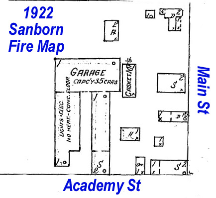
Main Street & Academy Street
Blacksmith Shop
(possibly Newton's Dwelling)
Key date analysis:
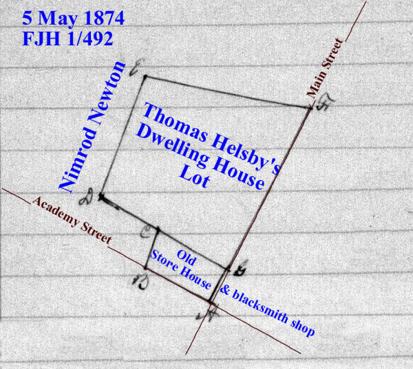
In 1852 Mary Bramble was taxed for a Blacksmith shop. She sold this lot to Thomas Helsby in 1861. When Thomas Helsby's estate was divided in 1874, the corner lot with a storehouse and blacksmith shop was given to Causine Helsby. He was taxed for a corner lot and shop in 1876. The square that appears on the 1877 map near the Northwest Corner of the main intersection is the blacksmith shop.
When Causine Helsby died in 1881, the land passed to his niece Emma Helsby. She began leasing the blacksmith shop to Edward Reed in 1889. After he died the lease was assigned to Walter E. Bonner (1898), Arthur M. Charles & Ella Charles (1901), Robert M. Rook & Lavenia A. Rook (1901), William S. Wright (1903), Howard J. Phillips (1904), and Clarence L. Saxton (1905). Emma Helsby Smith finally sold the property outright along with additional land to Clarence L. Saxton in 1919. The blacksmith shop appears on the 1922 map. Clarence Saxton likely moved the shop to its present location when he owned both parcels in the mid to late 1920s or in the 1930s. The Blacksmith Shop is now at the south end of Willoughby Casket Manufacturing building behind the Hometown Pride Market & Deli building.
Who built it:
The blacksmith shop was built before 1852.
Longest Residents:
Helsby, Reid, Saxton, and several others worked as blacksmiths at this shop.
More Research:
Historic Records:
The Blacksmith Shop is now at the south end of Willoughby Casket Manufacturing building behind the Hometown Pride Market & Deli. Clarence Saxton likely moved the shop to its present location when he owned both parcels in the mid to late 1920s or in the 1930s.
7 WHM 94 - 4 October 1919 - Emma H. Smith & James M. Smith, her husband, to Clarence L. Saxton and Harry E. Parker, co-partners, trading as Saxton & Parker for $700: Lot on the north side of Railroad Avenue in the town of East New Market. Beginning at a point on the north side of Railroad Avenue at a distance of S74/15E 134 feet from the west corner of a brick store building formerly owned by Jacob Millenson, the said store building situated at the east corner of Railroad Avenue and Main Street, from thence runs N15/45E 197.2 feet to an iron pin there planted, thence N76/22W 87.2 feet to another iron pin, thence S15/45W 194.4 feet to the north side of said Railroad Avenue and an iron pin, and from thence S74/15E 87.2 feet with the north edge of said Railroad Avenue to the place of beginning. Being the same land that was devised unto the said Emma H. Smith, by the last will and testament of Nimrod Newton.
1915-1917 Dorchester County Commercial Directory - East New Market
Clarence L. Saxton, blacksmith & agricultural implements
1912-1913 Dorchester County Commercial Directory - East New Market
Clarence L. Saxton, blacksmith & agricultural implements
1909-1911 Dorchester County Commercial Directory - East New Market
Clarence L. Saxton, blacksmith & agricultural implements
1906-1907 Dorchester County Commercial Directory - East New Market
Clarence L. Saxton, blacksmith & agricultural implements
30 CL 319 - 18 February 1905 - Howard J. Phillips & Lena M. Phillips, his wife, to Clarence L. Saxton to $575: Parcel in the town of East New Market on the road leading from East New Market to Secretary Creek. Beginning at the southwest corner of the lot on which the store house formerly occupied by Thomas J. Helsby stands, and west of the shop occupied by George W. Elliott, running thence with the street leading to Secretary Creek 40 feet, thence running back on a square with said road 85 feet, thence running on a parallel line with said road 40 feet to the line of the storehouse lot, thence a distance of 85 feet to the place of beginning. Being the same parcel granted unto Howard J. Phillips by deed dated 11 August 1904 in 29 CL 551. Subject to the payment of annual rent of $20.
29 CL 551 - 11 August 1904 - William S. Wright & Linda E. Wright, his wife, to Howard J. Phillips: [Described in 30 CL 319] Being the same land granted unto William S. Wright by deed dated 16 December 1903 in 28 CL 655.
28 CL 655 - 16 December 1903 -Levenia A. Rook & Robert M. Rook, her husband, to William S. Wright for $375: [Described in 30 CL 319] Being the same land granted unto Lavenia A. Rook by deed dated 30 August 1901 from Ella Chares & Arthur M. Charles, her husband.
1902-1903 Dorchester County Commercial Directory - East New Market
R.M. Rook, blacksmith
25 CL 720 - 13 August 1901 - Lease - Emma H. Smith & James M. Smith, her husband, to Lavenia A. Rook in consideration of annual rent of $20: Parcel in the town of East New Market. Beginning at the southwest corner of the lot on which the store house formerly occupied by Thomas J. Helsby stands, and west of the shop occupied by George W. Elliott, running thence with the street leading to Secretary Creek 40 feet, thence running back on a square with said road 85 feet, thence running on a parallel line with said road 40 feet to the line of the storehouse lot, thence a distance of 85 feet to the place of beginning. Being the same property described in a deed from William E. Johnson, surviving administrator of Edward W. Reed, deceased, to Walter E. Bonner, by deed 22 CL 126. The right, title, and interest of the said Walter E. Bonner in said property being afterward to wit: On January 28 1901, by deed granted unto Ella Charles in 25 CL 153. Lease for a term of ten years.
25 CL 153 - 28 January 1901 - Walter E. Bonner & Margaret Bonner, his wife, to Ella Charles for $600: parcel in the town of East New Market on the road leading from East New Market to Secretary Creek. Beginning at the southwest corner of the lot on which the store house formerly occupied by Thomas J. Helsby stands, and west of the shop occupied by James R. Stevens and running with the road leading to Secretary Creek 40 feet, thence running back and square with said road 85 feet, thence running parallel with said road 40 feet to the line of the said store house, thence 85 feet to the place of beginning. This being the same property at present occupied and used by Arthur M. Charles as a Blacksmith shop. This being also the same property which by lease dated 1 January 1889 to be recorded among the land records of Dorchester County, was leased unto Edward W. Reed by Emma H. Helsby. Being the same land described in a deed from William E. Johnson, surviving administrator of Edward W. Reed, deceased, to the said Walter E. Bonner in 22 CL 126. Lease for the annual payment of $25.
1899-1901 Dorchester County Commercial Directory - East New Market
A.M. Charles, blacksmith
22 CL 126 - 9 February 1898 - William E. Johnson, surviving administrator of Edward W. Reed, deceased, to Walter E. Bonner: Whereas William E. Johnson and Richard H. Stevens, administrators of Edward W. Reed, deceased, sold to Walter E. Bonner all the interest of the said Edward W. Reed in the property and leasehold estate hereinafter described on 29 September 1896. Whereas the purchase money was paid, but the administrators failed to convey by good and sufficient deed for that purpose. Richard H. Stevens, one of the aforesaid administrators hath died, leaving William E. Johnson as surviving administrator. Parcel in the town of East New Market on the road leading to Secretary Creek. Beginning at the southwest corner of the lot on which the store house formerly occupied by Thomas J. Helsby, but occupied at present by W. Albert Henry stands, and west of the shop occupied by James R. Stevens and running with the road leading to Secretary Creek 40 feet, thence running back and square with said road 85 feet, thence running parallel with said road 40 feet to the line of the said store house, thence 85 feet to the place of beginning. This being the same property at present occupied and used by the said Walter E. Bonner as a blacksmith shop. This being also the same property which by lease dated 1 January 1889 to be recorded among the land records of Dorchester County was leased unto the above named Edward W. Reed by Emma H. Helsby. Lease for the annual payment of $25.
1896-1897 Dorchester County Commercial Directory - East New Market
E.W. Reed, blacksmith
1896-1910 Tax Record
Edward W. Reed
1896 -
Blacksmith shop on North side of Street from ENM to Secretary $300
1 old house in rear of shop $5
20 May 1898 - reduced by Blacksmith Shop to W.E. Bonner
W.E. Bonner
20 May 1898 - Blacksmith Shop from E.W. Reid $300
3 January 1898 - reduced by Blacksmith Shop to A.M. Charles $300
Robert Rook
19 May 1903 - Blacksmith Shop from A.M. Charles $300
10 May 1904 - reduced by Blacksmith Shop to Wm S. Wright
Mary A. Elliott
1 house on leased land on Railroad Ave. $25
5 May 1910 - reduced by house on leased land to C.L. Saxton
C.L. Saxton
26 April 1907 - House on leased land Railroad Avenue ENM from Mary A.
Elliott $25
6 May 1907 - Blacksmith shop from Wm S. Wright $300
1896 Tax
Record
Edward W. Reed
Blacksmith shop situated on the north side of the street leading from
East New Market to Secretary $300
1 old house in rear of shop $5
blacksmith shop $50
1894-1895 Dorchester County Commercial Directory - East New Market
E.W. Reed, blacksmith
1891-1892 Dorchester County Commercial Directory - East New Market
E.W. Reed, blacksmith
1 January 1889 - Lease - Emma H. Helsby to Edward W. Reid. Annual Payment of $25
1880 Dorchester County Commercial Directory - East New Market
Charles Reid, wheelwright
East New Market Cemetery
Margaret Newton 10 April 1885 aged 81 years, wife of Nimrod.
1880 Dorchester County Commercial Directory - East New Market
E.W. Reed, wheelwright
East New Market Cemetery
Causine Helsby d. 13 April 1881
1880 Dorchester County Commercial Directory - East New Market
E.W. Reed, wheelwright
Charles Reed, wheelwright
1876 Tax
Record
Causine Helsby
1 corner lot & shop in ENM 1/8 acre - $300
1 FJH 492 - 5 May 1874 - Causine Helsby to divide the lands of Thomas Helsby, deceased: A certain Thomas Helsby departed this life in the year 1865, intestate, and seized of certain real estate in the town of East New Market and leaving Frelinghuysen Helsby and your petitioner, the said Causine Helsby his only children and heirs at law, but the said Frelinghuysen Helsby departed this life, intestate, in the year 1872, leaving Emma Helsby his only child and heir at law, who is an infant under the age of 21 years. The petitioner prays that a commission fairly and equally in value between the parties interested. A commission of Kendall M Jacobs, John WM Dean, John W Fletcher, Thos K Smith, and Thos Leckie was appointed. The real estate situated in the town of East New Market consisting of a dwelling house & lot including an old store house & blacksmith shop on the same, and an arable lot of land detached from the dwelling house and lot and adjoining the school house in said town. Running a line from a stone on the Main Street straight to a stone near the fence of Nimrod Newton giving and allowing to Emma Helsby, infant child of Frelinghuysen Helsby, all of the lot and dwelling house and other buildings on the north of said straight line. To the said Causine Helsby, all that part of the house & lot above described lying on the south side of the line as above described running from the Main Street then intersecting with the said Nimrod Newton's fence including the old store house and blacksmith shop and also the lots of arable land detached as above described. (near the Episcopal Church of East New Market, beginning at the east corner of the primary school lot.
1870 Census
Possibly dwelling #362, household of Mariah Reid
1867-1876 Tax Record
Sarah Jane Helsby
1867 - House & Lot $800
1867 - unimproved lot $150
1866 Tax
Record
Sarah Jane Helsby
house & lot $800, unimproved lot $150
5 FJH 134 - 15 November 1861 - Mary Bramble to Thomas Helsby for $325: lot in the town of East New Market bounded on the east by the county road leading to Cabin Creek and on the south by the road leading to Secretary Creek. Also adjoining lot known as the McCollister Lot and purchased by the said Mary Bramble at the sale of the real estate of Jeremiah Bramble, deceased, and bounded in part on the east by the first described lot and on the south by the said road leading to Secretary Creek.
1852-1864 Tax Record
Thomas Helsby
1862 Lot in New Market from Mary Bramble $200
Mary Bramble
House & Lot $800, Blacksmith's Shop $200, Lot, Shop $100
.....reduced
1862 by lot sold to Thos Helsby $100
1850
Census
Thomas Helsby was a wheelwright in dwelling #381
Marriage - 27 March 1843 - Dorchester County
Thomas Helsby to Sarah J. Newton
20 HD 398 - 25 October 1802 - Commission Certificate to Joseph
Ennalls, John Stevens, Joseph Whiteley, Edward Whiteley and William
Ennalls, gentlemen. Henry King petitions the court that a certain John
Anderton Mitchell died intestate and seized of lands in Dorchester
County. Your petitioner and a certain Mary King, sister of your
petitioner, of full age, and a certain Mary King the only child and
daughter of a certain Edward King, who was a brother of your petitioner
and is now dead, are entitled to the said lands by inheritance as heirs
at law and representatives of the said John Anderton Mitchell, deceased.
The Mary King, last aforesaid, is a minor. Your petitioner therefore
prayed that the said court will appoint a commission to divide the
lands. Notice was given to Betsy King who the court appointed as
guardian of the said Mary King, who is a minor under the age of 21
years. The Commission estimated the value of the land at 3618 pounds and
divided it.
Re ---For Henry King, 3 parts valued at 1206 pounds:
(2) Beginning for the 2nd lot layed out for Henry King composed of
Sundry parts of tracts of land at the end of 58 perches on the second
line of the land that John Rix sold to John Anderton where stands a
cedar post as No. V at L on the plot and from thence, runs N 75 W 30
perches to another cedar post as No. VI at Q on the plot, then S 17 W
116? 1/2 perches to the main road that leads down to Henry Dickinson's
farm then S 75 E 29 1/2 perches until it comes parallel with the west
side of the granary then N 15 E 3 perches to a cedar post a No. VII at R
on the plot then S 75 E to the main road that leads from New Market to
Cabin Creek and then with the said road to the place of beginning.
Containing 9 1/4 acres.
Re ---for Mary King, daughter of Edward King, deceased, land valued at
1206 pounds
(2) one other lot whereon the Granary
stands. Beginning for said lot at the end of the 3rd line of Henry Kings
9 1/4 acre lot and then runs N 15 E 8 perches to a cedar post as No. VII
at R on the plot, then S 75 E to the main road that leads from Cabin
Creek to Cambridge then S 15 W 18 perches to the main road that leads
from Crotcher's Ferry to Henry Dickinson's farm and then with a straight
line to the place of beginning. Containing 9 square perches of land.
25 Old 9 - 13 June 1771 - Francis Anderton, planter, to John Anderton, merchant, for 10 pounds and a tract called "Sandwich" in the forks of Cabin Creek's branches: (3) Also part of a tract called "Buckland" and part of a tract called "Debate Enlarged", being the land granted by a certain John Rix to the aforesaid John Anderton, deceased. Beginning at the end of 6p in an E course drawn from a marked live oak standing in the edge of a swamp in the fork of Secretary's Creek, being the beginning tree of said John Anderton, deceased, his part of a tract called "Bath", then runs still E 32p, then N 172 1/2p, then E 3p, then N to the branch, then binding with the branch until it intersects a N course from the beginning. Containing 50 acres. John Anderton, deceased, is the father of said Francis Anderton.
11 Old 200 - 29 June 1743 - John Rix to John Anderton in consideration of 50 acres of land lying in the fork of Secretary's Creek being a part of a tract of land called "Westward" as by deed bearing equal date with there presents may more fully appear: land being a part of "Buckland" and part of "Debate Enlarged". Beginning at the end of 6p in an east course drawn from a marked live oak standing in in the leg of a swamp in the fork of Secretary's Creek, being the beginning of said Anderton's part of a tract Bath, then runs still East 32p, then N 172 1/2p, then E 3p, then N to the branch, then binding with the branch until it intersects a north course from the beginning. Containing 50 acres.